

Ancient Paths and Historical Itineraries of Sicily: V Via Selinuntina (Syracuse – Agrigento – Trapani)
Rev. B1.1 (edited by Ignazio Caloggero)
ROUTE MODIFIED – TEXT BEING UPDATED.
Interactive map updated in real time. For a global view of all the historical itineraries of Sicily, for the presentation of the project, the "zoomable" historical maps taken as reference and the relative methodological notes, please refer to the project page: Ancient paths and historical itineraries of Sicily. For a view of all the routes in one web page, see: Ancient Paths and Historical Itineraries of Sicily: All the routes live.
The map shows the main "stations" and the archaeological sites encountered along the way. Under the map further details and technical notes. The total length of the path affected by this route is approximately 620 km.
Note: Along the way, some cross roads connected in some way to via Selinuntina and via Maritima Loca should also be considered. Only the Floridia-Canicattini Bagni and Terravecchia-Acate cross roads have been left on this page, as they could be considered variants of the Via Selinuntina. For a broader view that takes into account other transversal routes and connections with other paths, including the Via Maritima Loca, we recommend viewing the cumulative interactive map of the South East grid
For a better view of the path
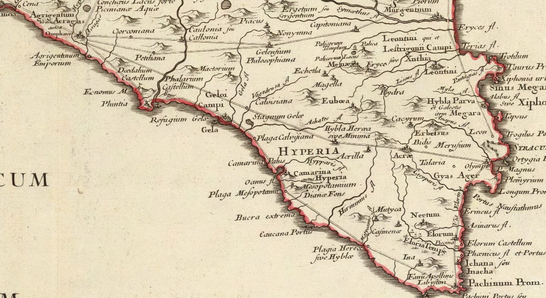
C12: Siciliae Antiquae quae et Sicania et Trinacria dicta tabula geographica (1714)
Path
The route of the Via Selinuntina has been studied by various authors, among these the following stand out: Holm[1]Biagio Pace[2] and Giovanni Uggeri[3]. Please refer to the end of the chapter for the bibliographic and cartographic list I used.
Via Selinuntina is so called on the basis of the inscription found ad Akray (Palazzolo Acreide) which talks about a door to Selinunte.
Existing in the seventh century BC, used by Syracuse to reach the colonies of Akray e Kasmenai (Monte Casale), crossed in the XNUMXth century BC by the army of Selinunte to reach Syracuse[4], and in the IV by the army of Dione which in three days arrived from Heraclea to Syracuse[5]. In Roman times, the road that reached Selinunte in Greek times was extended up to Trapani.
A first reconstruction that refers to the Tabula Peutingeriana and indicated in the map C28: Siciliae Antiquae Tabula (1834) is the following:
- SIRACUSA
- Palazzolo Acreide (Agris, Akray, Acre)
- Ragusa (Hyble, Hybla Herea [sive Minima]
- Calvisiana
- Agrigento
- Price
- Allava
- Sciacca (Labodes Water)
- Lanaricum River
- Mazara
- Lilybeum (Marsala)
- Trapani (Drepanum)
References B. Pace (3), G. Uggeri (21), C12, C28 and C29,
[1] Adolfo Holm: History of Sicily in Antiquity Vol. III Chap IV
[2] Biagio Pace: Art and Civilization of Ancient Sicily Vol. 1 pag. 475 (1958)
[3] Giovanni Uggeri: see documents (1), (3), (11), (15), (17) indicated in the bibliography
[4] Thucydides Lib VI.66, 101
[5] Giovanni Uggeri: The formation of the Roman road system in Sicily. Page 229 note 19.
Synthetic route
Syracuse – Agrigento
- Section V1 (Syracuse – Palazzolo Acreide)
-
- Variant V1.a (Syracuse – Canicattini Bagni – Palazzolo Acreide) (ABC)
- Variant V1.b (Syracuse – Floridia – Canicattini Bagni – Palazzolo Acreide) (A- DBC)
- Section V2 (Palazzolo Acreide – Giarratana)
- Section V3 (Giarratana – Ibla)
- Section V4 (Ibla – Comiso)
- Section V5 (Comiso – Acate)
- Section V6 (Acate – Niscemi)
- Section V7 (Niscemi – Butera)
- Section V8 (Butera – Riesi – Ravanusa)
- Section V9 (Ravanusa – Agrigento)
Transversal and further connecting routes which could also be indirectly connected to the Via Selinuntina
- Transversal T1: Floridia – Canicattini Bagni
- Transversal T2: Terravecchia – Gulfi – Acate
- Transversal T3: Comiso-Giarratana (B. Pace 3.477, 3.193)
Summary of traits, sub-tracts and variants
Section V1 (Syracuse – Palazzolo Acreide)
Variant V1.a – (Syracuse – Canicattini Bagni – Palazzolo Acreide)
- SIRACUSA
- V1.a.1: (Porta Urbica) (C4-C7)
- V1.a.2: Palude Lisimelia (Pantanelli) (36 – Fazello) (C4-C7).
- V1.a.3: Contrada Pantanelli (3.477 B. Pace) (36 Fazello) (C30) (C26) (C17) (CAMS)
- V1.a.4: Temple of Zeus (CAMS) (3.477 B. Pace) (C30) (C26) (C12) (C29)
- V1.a.5: Rinaura (99) (CAMS) (C30) (C26)
- V1.a.6: Cozzo Pantano (3.477 B. Pace) (CAMS)
- V1.a.7: Contrada Lancarossa (CAMS) (C26) (C30)
- V1.a.8: Masseria Grotta Perciata (CAMS)
- V1.a.9: Cozzo Guardiole (CAMS) (C26) (C30)
- V1.a.10: Canicattini Bathrooms (CAMS) (3.477 B. Pace) (C26) (C27) (C30)
- V1.a.11: Ciaramiro (CAMS) (C26) (C30)
- V1.a.12: VAb.3: Passoladro (CAMS) (C26) (C30)
- V1.a.13: Cava Cinque Porte (near) (CAMS)
- V1.a.14: Cava Pantalica (CAMS)
- V1.a.15: Contrada Saraceni (CAMS)
- V1.a.16: Contrada Porticaletto (CAMS)
- V1.a.17: Colle Pinita – Torre Judica (CAMS)
- Palazzolo Acreide (CAMS) (C4-C7) (C12) (C26) (C27) (C28) (C29) (C30) (3.475 B. Pace)
Variant V1.b (Syracuse – Floridia – Solarino – Palazzolo Acreide)
- SIRACUSA
- V1.b.1: (Porta Urbica) (C4-C7)
- V1.b.2: Fusco – Regina (CAMS) (C26) (C27) (C30)
- V1.b.3: Contrada Canalicchio (CAMS) (C26) (C30)
- V1.b.4: Floridia (3.477 B. Pace) (CAMS) (C4-C7) (C26) (C27) (C30)
- V1.b.5: Cozzo Collura (CAMS) (C26) (C30)
- V1.b.6: Solarino (C26) (C30)
- V1.b.7: Contrada Campocasa (CAMS) (C26) (C30)
- V1.b.8: Contrada Colle Orbo (CAMS) (C26) (C30)
- V1.b.9: Cugno Quercia (CAMS) (C26) (C30)
- V1.b.10: Contrada Fondi Nuovi (CAMS) (C26) (C30)
- V1.b.11: Contrada Porticaletto (CAMS) (V1.a)
- V1.b.12: Colle Pinita – Torre Judica (CAMS) (V1.a)
- Palazzolo Acreide (V1.a)
Transversal T1: Floridia – Canicattini Bagni
- Floridia
- T1.1: Soprano Monasteries (CAMS) (C26)
- T1.2: Cugno Trappetazzo
- T1.3: Diego Houses
- T1.4: Cisternazza (CAMS) (C26) (C30)
- T1.5: Masseria Bagni (CAMS)
- T1.6: Cava Bagni (CAMS) (C26) (C30)
- Canicattini Bathrooms
Section V2 (Palazzolo Acreide – Giarratana)
- Palazzolo Acreide (CAMS) (C4-C7) (C12) (C26) (C27) (C28) (C29) (C30) (3.475 B. Pace)
- V2..1: Monte Casale (3.476) (CAMS) (C30)
- V2.2: Terravecchia (Cerretanum Jarratanae) (C4-C7) (CAMS) (C26) (C30) (3.476 B. Pace)
- V2.3: Giarratana (Imperial Villa of Orto Mosaico) (CAMS) (C30)
Section V3 (Giarratana – Ibla)
- V3.1: Giarratana (Imperial Villa of Orto Mosaico) (CAMS) (C30)
- V3.2: Roman Villa of Margi (CAMS) (C30)
- V3.3: Red Cliff (CAMS) (C30)
- V3.4: Ibla (Hible) (S3) (3.475) (C13) (C14) (6) (C4) (C26), (9) (13.302) (C12) (C29)
Section V3 (Giarratana – Ibla)
- V3.1: Giarratana (Imperial Villa of Orto Mosaico) (CAMS) (C30)
- V3.2: Roman Villa of Margi (CAMS) (C30)
- V3.3: Red Cliff (CAMS) (C30)
- V3.4: Ibla (Hible) (S3) (3.475) (C13) (C14) (6) (C4) (C26), (9) (13.302) (C12) (C29)
Section V4 (Ibla – Comiso)
- Variant V4.a: Ibla – Scassale – Comiso
- Ibla
- V4.a.1: Cava San Leonardo (CMAS) (C30)
- V4.a.2: Cava Scassale (3.476) (CAMS) (C26) (C30)
- V4.a.3: Contrada Castiglione (C26) (C30)
- V4.a.4: Coast of Monaco (CAMS)
- V4.a.5: Cozzo Apollo (hips) (3.476) (CAMS)
- Comiso
- Variant V4.b: Ibla – Cisternazzi – Comiso
- Ibla
- V4.b.1: Contrada Rito (CAMS)
- V4.b.2 Petrulli pendant
- V4.b.3: Contrada Tabuna (CAMS)
- V4.b.4: Cisternazzi (Mansio Romana) (CAMS)
- V4.b.5: Centro Pozzi (3. 476) (CAMS)
- V4.b.6: Musebbi (CAMS)
- V4.b.7: Tresaurus (3. 476) (CAMS)
- V4.b.8: San Leonardo district (CAMS)
- Comiso (3.476) (CAMS)
Transversal T2 (Giarratana – Chiaramonte Gulfi – Acate)
- Giarratana
- T2.1: Walls (CAMS) (C30) (C26)
- T2.2: Saint Lucia (C30) (C26)
- T2.3: Oranges-Marana- Piano Conte (Akrillai) (CAMS) (C30) (C26) (C7) (C28)
- T2.4: Bed bug CAMS) (C30) (C26)
- T2.5: Sperlinga (CAMS) (C30) (C26)
- T2.6: Round Pit (CAMS) (C30) (C26)
- T2.7: Scornavacche (CAMS) C26) (C30)
- T2.8: Arceri Plan (CAMS) (C30)
- T2.9: Contrada Biddine (C30) (3.476) (C26)
- acate
Section V5 (Comiso – Acate)
- Comiso
- V5.1: King's Clash (CAMS) (C26) (C30)
- V5.2: Contrada Martorina (Vittoria) (CAMS) (C26) (C30)
- V5.3: Contrada Maritaggi (C26) (C30)
- V5.4: Borgo Serra San Bartolo (C26) (C30) (3.476)
- Achates (C30)
Section V6 (Acate – Niscemi)
- V6.1: Torrevecchia (C26) C30)
- V6.2: Case Caruso (CAMS) (CAMS) C26) (C30)
- V6.3: Contrada Iacono (CAMS) C26) (C30)
- V6.4: Pirrera Plan (CAMS) C26) (C30) (C7)
- V6.5: Casa Mastro (Calvisiana) (C14) (C26) (13.302) (13.302) (C12) (C29) (C7) (C12) (C30)
- V6.6: Pantanelle Pass (C26) (C30)
- V6.7:: Priolo (3.476) (C30) (C26)
- V6.8: Niscemi (3.476) (CAMS) (C30) (C26)
Section V7 (Niscemi – Butera)
- Niscemi
- V7.1: etruded (CAMS) (C30) (C26)
- V7.2: Camera Plan (CAMS) (C30) (C26)
- V7.3: Contrada Desueri (CAMS) (C30) (C26)
- V7.4: Contrada Pozzillo (C30) (C26)
- Butera (3.476) (C4) (6) (3.476) (CAMS)
-
Section V8 (Butera – Riesi – Ravanusa)
- Butera
- V8.1: Mallo River (CAMS) (C30) (C26)
- V8.2: Monte Priorato (near) (CAMS) (C30) (C26)
- V8.3: Riesi (3.476) (CAMS) (C30) (C26)
- V8.4: Monte Bosco/Monte Oliveto/Serra Perciata (near) (CAMS) (C30) (C26)
- Ravanusa (Monte Saraceno) (3.476) (CAMS) (C26) (C30) (Callonian?) (22.484)
Section V9 (Ravanusa – Agrigento)
- Ravanusa (Monte Saraceno) (3.476) (CAMS) (C26) (C30) (Callonian?) (22.484)
- V9.1: Contrada Milici (C26) (CAMS) (C26) (C30)
- V9.2: Campobello di Licata (99)
- V9.3: Contrada Tre Fontane (CAMS) (C30)
- V9.4: Case Schembari (near) (CAMS) (C30)
- V9.5: Castellazzo di Camastra (near) (CAMS)
- V9.6: Contrada Balate (CAMS)
- V9.7: Contrada Canale (CAMS)
- V9.8: Naro (3.476) (CAMS) (Corconiana?) (A. Holm 22.484)
- V9.9: VEa.25: Favara (3.476)
- Agrigento (S5) (3.475) (C13) (C14) (C30)
-
Note on Rocca Stefano (CAMS)
Agrigento – Trapani
Section V10 (Agrigento – Montallegro)
- Agrigento
- V10.1: Contrada Addolorata Macello (CAMS) (C26)
- V10.2: Porto Empedocle (C26)
- V10.3: Contrada Durrueli (CAMS) (C26)
- V10.4: Casa Biondi (CAMS)
- V10.5: Capo Rossello (CAMS)
- V10.6: The Capreria (C26)
- V10.7: Contrada lo Mbiso (or Nbiso) (C26)
- V10.8: Sella Omomorto (CAMS)
- Dinner (Monteallegro) (5) (4.472-473) (22.484 Monteallegro) (C26)
Section V11 (Montallegro – Sciacca)
- Dinner (Monteallegro) (5) (4.472-473) (22.484 Monteallegro) (C26)
- V11.1: Laghetto del Gorgo (C26) (C30)
- V11.2: Eraclea Minoa (La Collinetta) (C30) (C26 – Strada di Sciacca) (CAMS) (12.303)
- V11.3: Borgo Bonsignore (CAMS)
- V11.4: Casa Campello (near) (CAMS)
- V11.5: Allava (Contrada Verdura) (5) (8) (4.472-473) (22.484 maybe Ribera) (CAMS) (C26)
- V11.6: Contrada Salinella (CAMS)
- V11.7: Contrada Carabollace (CAMS)
- Sciacca (Acquas Larodes or Acquae Labodes) (5) (4) (8) (4.472-473) (22.485) (11.37) (12.303)
Section V12 (Sciacca – Mazara del Vallo)
- Sciacca (Acquas Larodes or Acquae Labodes) (5) (4) (8) (4.472-473) (22.485) (11.37) (12.303)
- V12.1: Laghetto Foce del Carboj/Località Maragni (C30) (C26) (CAMS)
- V12.2: Mouth of the Varvaro (C30) (C26) (CAMS)
- V12.3: Contrada Malopurtetto (C30) (C26) (CAMS)
- V12.4: Contrada Cavallaro/Dimina
- V12.5: Contrada Guglitti (CAMS) (C26)
- V12.6: Contrada Allegra – Margio (CAMS) (C26)
- V12.7: Case Saporito – Muretta (CAMS) (C26)
- V12.8: Fl Lanaricum (Selinis) (now Modione River) (5) (7) (8) (4.472-473) (“on the Selinunte river” 22.485)
- V129: Campobello di Mazara (Erbe Bianche – Santo Monte) (CAMS) (C26) (C4-C7) (C27)
- V12.10: Torre Cusa Burgio (CAMS)
- V12.11: Contrada S. Nicola (C26) (CAMS) (C30)
- V12.12: Dubesi (C26) (CAMS) (C30)
- Mazzara del Vallo (Mazaris) (5) (4.472-473) (C26) (C30) (C4-17) (C27)
Section V13 (Mazara del Vallo – Trapani)
- Mazzara del Vallo (Mazaris) (5) (4.472-473)
- V13.1: Giangreco (C26) (CAMS)
- V13.2: The Arches (CAMS)
- V13.3: Contrada Guletta (CAMS)
- V13.4: Casale Nuovo (CAMS)
- V13.5: Contrada Mirabile (CAMS)
- V13.6: Contrada Perrone (CAMS)
- V13.7: Contrada Mola (CAMS)
- Marsala (Lilybaeum) (5) (4) (4.472-473) (C30) (C26)
- Mozia (CAMS)
- Trapani
Insights
C28: Siciliae Antiquae Tabula (1834)
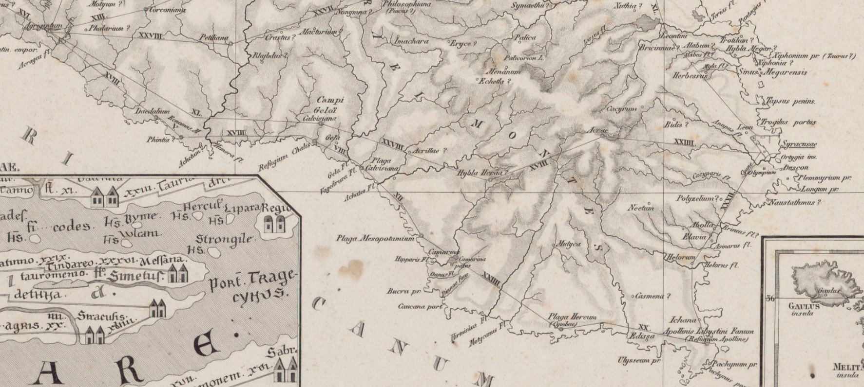
C7: Sicily (1799) – detail of the Hyblean section
Bibliography and Reference Cartography.
(1) (3) (11) (13) (14) (15) (17) (22) (26) (29) (35) (36) (40) (42) (99) (CAMS) (C4 ) (C7) (C12) (C13) (C15A) (C16) (C17) (C18) (C26) (C27) (C29) (C30)
- [1] Giovanni Uggeri: The formation of the Roman road system in Sicily
- [3] Biagio Pace: Art and Civilization of Ancient Sicily Vol. 1 pag. 453-488
- [11]: Patitucci - G. Uggeri, Contribution to Tabula Imperii Byzantini of Sicily: the Ippari Valley, in SAMI, Proceedings VII Congr. Nat. arch. Med. (Lecce 2015), Florence 2015, pp. 436-41.
- [13]: G. Uggeri: Itineraries and roads, routes, ports and ports of call of late ancient Sicilyin Proceedings IX Ancient Sicily Congress (Palermo 1997), "Kokalos" 43-44 (1997-1998), Rome 2000, pp. 299-364.
- [14]: The Roman road system in Sicily and the medieval remains. Extract from: ROCK SICILY IN THE CONTEXT OF MEDITERRANEAN CIVILIZATIONS Proceedings of the sixth International Study Conference on Medieval Rock Civilization in Southern Italy (Catania - Pantalica - lspica, 7-12 September 1981) - Congedo Editore Galatina - 1986
- [15]: G. Uggeri: The Roman road system in Sicily with particular regard to the third and fourth centuries. In Kokalos XXVIII-XXIX 1982-1983
- [17]: G. Uggeri: Sicily in the "Tabula Peutingeriana" - Editore Loffredo - Naples 1968
- [22] Adolfo Holm History of Sicily Antiquity Vol. III Chap IV
- [26] Biagio Pace: The most recent excavations of Camarina in the Historical Archive for Eastern Sicily Year XIV - File I, II, II (1917)
- [29]: Corrado Fianchino, Gaetano Sciuto: The paths of naturalness in the south-east of Sicily - Aracne Edittrice - 2017
- [35] Francesca Buscemi: Ancient routes and modern travelers through the Iblei. Notes on historical topography in: Archaeological landscapes of south-eastern Sicily. Rosolini's landscape curated by Francesca Buscemi and Francesco Tomasello - published as part of the Progetto KASA 2008 project (Koinè Archeologica, Sapiente Antichità) funded under the Interreg IIIA Italy-Malta program, 2004-2006
- [36] Tommaso Fazello - History of Sicily Volume I. Palermo
- [40] Thucydides - The Peloponnesian War Vol. VI, VII
- [42] Giorgio Bejor - Aspects of the Romanization of Sicily. In: Modes de contacts et processus de transformation dans les sociétés anciennes. Actes du colloque de Cortone (24-30 mai 1981) Rome: École Française de Rome, 1983. pp. 345-378. (Publications de l'École française de Rome, 67);
- [99] Ignazio Caloggero: The Project Ancient Paths and Historical Itineraries of Sicily
- CAMS: Multimedia Archaeological Map of Sicily - Link: https://www.lasiciliainrete.it/archivio-patrimonio-archeologico-di-sicilia/
- C4: Nova et accurate Siciliae Regionum, Urbium, Castellorum, Pagorum Montium, Sylvarum, Planitierum, Viarum Situum ac Singularium quorumque locorum et rerum ad Geographiam Partinentium Descriptio Universalis - 1721 author Schmettau, Samuel von
- C7: Sicily. Publisher: Robert Laurie & James Whittle (1799) (always referable to Schmettau's paper))
- C12: Siciliae Antiquae quae et Sicania et Trinacria dicta tabula geographic. Publisher: L'Isle, Guillaume de, 1675-1726
- C13: [4] Tabula Peutingeriana (medieval map of the Roman world written by a monk of Colmar XIII century
- C15A: General Map of the Island of Sicily - Officio Topografico 1826 (South-East)
- C16: Guidelines of the Regional Territorial Landscape Plan - Historic road network
- C17: Syracuse at the time of Gelone and Gelone I map with the roads leaving Syracuse attached to the book by Adolfo Holm: Storia di Sicilia-Vol. THE
- C18: Sicily Trazzerale Network (1929). Published in the Journal of the Land Registry and Tax Services in 1941
- C26: Europe in the XNUMXth century. century (with the Third Military Survey)
- C27: Comparative Map of Modern Sicily (1859)
- C28: Siciliae Antiquae Tabula (1834) (Sicily Tabulae Peutingerianae)
- C29: La Sicile Pour l'Histoire Romaine (1740)
- C30: Cartography of the Landscape Plans of the Sicily Region which can be consulted online (for the trazzere and historical routes)
- [36] Tommaso Fazello - History of Sicily Volume I. Palermo
For the bibliography and general cartography see the page: Methodological Notes and Bibliography
Technical and methodological note
The Multimedia Map of the Ancient Historical Routes is created in two sub-phases (not necessarily sequential):
- Phase A (Basic Path): in the first sub-phase the paths are identified in the form of a first draft divided into segments and sections (taking into account the bibliography, the historical maps analyzed and the Multimedia Archaeological Map of Sicily (CAMS) and only partially the paths on the ground). The basic route is the starting point proposed to the scientific community, preparatory to the subsequent phase of detailed analysis of the individual segments that make up the entire identified path
- Phase B (Advanced Path): in the second phase, an incremental refinement process will begin by adapting, as faithfully as possible, the individual components that make up the route to the historical routes and to the tracks on the ground and where the ancient traces have been lost, adapt them to the current routes that are closest to the ancient paths (keeping track of the historical paths, where identified). The incremental refinement process will also take into account historical roads, natural roads and further studies and contributions from the scientific community and scholars in the sector.
- Phase C (Subdivision of the paths): When fully operational, the project provides for the drafting of two paths that may diverge in some points: a path as faithful as possible to the ancient path regardless of its current practicability and another that could form the basis for proposing itineraries that take into account the actual practicability and the possibility of enjoying the historical, artistic and naturalistic beauties close to the historical route.
Note: In cases where the ancient route is no longer identifiable or has been completely replaced by high-speed roads, or obstructed by industrial plants or other types of impediment, an attempt has been made to identify a stretch that in some way is closest to the characteristics of a naturalistic path or in any case a substitute for the fast-flowing path. In some cases, moreover, in case of doubt between two possible routes, the route that allows you to pass in the immediate vicinity of landscapes or cultural heritage considered interesting from a tourist-cultural point of view has been taken into consideration.
