

Ancient Walks and Historical Itineraries of Sicily: IV Agrigento - Palermo
Phase B: Rev 1.0 (edited by Ignazio Caloggero)
Interactive map updated in real time. For a global view of all the historical itineraries of Sicily, for the presentation of the project, the "zoomable" historical maps taken as reference and the relative methodological notes, please refer to the project page: Ancient paths and historical itineraries of Sicily. For a view of all the routes in one web page, see: Ancient Paths and Historical Itineraries of Sicily: All the routes live.
The map shows the main "stations" and the archaeological sites encountered along the way. Under the map further details and technical notes.
Description
From the Itinerarium Antonini we have the following route;
- Agrigento
- Pitinianis
- Comicianis
- Petrine
- Pirina
- Palermo

Da C12: Siciliae Antiquae quae et Sicania et Trinacria dicta tabula geographica (1714)
According to Biagio Pace (3.474), between Castronuovo and Vicari, near Lercara, a second branch of the Agrigento road, was directed towards the sea, in a north-easterly direction and ended up near Imera.
Based on these elements, the following traits have been hypothesized.
- VAT Section (Agrigento – San Luca)
- Section IVB (San Luca – Palermo)
- Section IVB1 (San Luca – Corleone – Palermo branch)
- Section IVB2 (San Luca branch – Misilmeri – Palermo)
- Probable Transversal IVT1 for Imera (Contrada La Catena – Alia – Caltavuturo) (3.482)
- Probable VT2 cross road for Imera (Roccapalumba – Regalgioffoli – Termini Imerese) (18.334)
Below is the detailed description
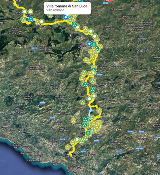
VAT Section (Agrigento – San Luca)
- Agrigento (3.474)
- VAT.1: Contrada Minaga (CAMS)
- VAT.2: St. Michael (18.334)
- VAT.3: Rocca Perciara (CAMS)
- VAT.4: St. Vincent (C26)
- VAT.5: Contrada Capo (CAMS)
- VAT.6: Puzzu Rosi (CAMS)
- VAT.7: Comitini (Comicianis?) (3.475), (6) (8) perhaps at Comitiana (18.334) (C7) (C27)
- VAT.8: Cozzo Doctor (CAMS)
- VAT.9: Serra Sabedda (CAMS)
- VAT.10: Cantarella (C26)
- VAT.11: Funnuto Pass (18.334) (C26)
- VAT.12: Contrada Gorgalonga (CAMS)
- VAT.13: Casteltermini (C26) (C27) (C7) (18.334)
- VAT.14: Contrada Petix (C26) (CAMS)
- VAT.15: Contrada Case Lo Bue (CAMS) (C26)
- VAT.16: Contrada Fabbrica (C26) (CAMS)
- VAT.17: Contrada Giardinello (CAMS) (C26)
- VAT.18: Cozzo Gilferraro (CAMS) (C26)
- VAT.19: Trabia (18.334) (C26)
- VAT.20: Contrada Gilferraro/Rocca di Cippa (CAMS) (C26)
- VAT.21: Contrada Don Matteo (CAMS) (C26)
- VAT.22: Cammarata station (6) (C4) (C7) (Pitiniana?) (18.334) (C26) (C16) (*)
- VAT.23: Contrada Passo del Barbiere (C26)
- VAT.24: Saracen Bridge (C26)
- VAT.25: St. Peter's Bridge (C26)
- VAT.26: Castronuovo di Sicilia (3.474), (6) (c16) (C4) (C26) (C27) (18.334)
- VAT.27: Contrada Santa Caterina (CAMS) (C26)
- VAT.27: St. Luke (CAMS)
Section IVB (San Luca – Palermo)
Section IVB1 (San Luca – Corleone – Palermo branch)
- San Luca - Corleone - Palermo branch
- IVB1.1: Hospitalization of Filaga (18.334) (C26) (CAMS)
- IVB1.2: Horse Mountain (Hyppana) (CAMS)
- IVB1.3: Trojan (CAMS)
- IVB1.4: Contrada Spolentino (CAMS) (C26)
- IVB1.5: Contrada Zuccarone (18.334) (59) (64) (65) (66) (C26)
- IVB1.6: Cozzo Bisagna (CAMS) (18.334) (C26)
- IVB1.7: Contrada S. Elena (Corleone) (CAMS) (C1) (C2) (C26)
- IVB1.8: Casale Bridge (C26)
- IVB1.9: Rocca Argenteria – Piano Casale (CAMS) (C26) (18.334)
- IVB1.10: Masseria Castellaccio (CAMS)
- IVB1.11: Contrada Quadaredda (CAMS)
- IVB1.12: Monte Rossella (CAMS)
- IVB1.13: Contrada S. Agata (18.334) (CAMS)
- IVB1.14: Kuri i Abilities (CAMS)
- IVB1.15: Location Maganoce (Malanoce) (CAMS) (C26)
- IVB1.16: Saint Christina of Gela (18.334) (CAMS) (C2) (C26) (C27) (C7)
- IVB1.17: Rebutton (18.334) (C26)
- IVB1.18: Cozzo di Castro (18.334) (CAMS)
- IVB1.19: Malpasso (18.334) (C26)
- IVB1.20: Bridge of Grace (18.334) (C26)
Section IVB2 (San Luca branch – Misilmeri – Palermo)
- San Luca - Misilmeri - Palermo branch
- IVB2.1: Lercara (3.474)
- IVB2.2: Colle Madore (CAMS)
- IVB2.3: Contrada Friddi (CAMS)
- IVB2.4: Vicars (Pirama) (3.474), (6) (C4) (CAMS)
- IVB2.5: Shepherd (C26)
- IVB2.6: Basiliuni (C26)
- IVB2.7: Contrada San Lorenzo (Villafrati) (C26) (3.474)
- IVB2.8: Contrada Cefale (C26)
- IVB2.9: Chiarastella Lace (CAMS)
- IVB2.10: Baths of Cefalà Diana (CAMS) (C27)
- IVB2.11: Contrada Fiduccia (CAMS)
- IVB2.12: Ogliastro (3.474) (C26) (C27) (C7)
- IVB2.13: Cozzo Crossbowmen (C26)
- IVB2.14: Scalambra (C26)
- IVB2.15: Mysilmers (3.474), (6) (C4) (C27) (C7)
- IVB2.16: Sea Portella (3.474) (C26)
- IVB2.17: Villabate (C26) (C27)
- IVB2.18: Torrelunga (C26)
- Palermo (3.474), (6) (C4) (18.334)
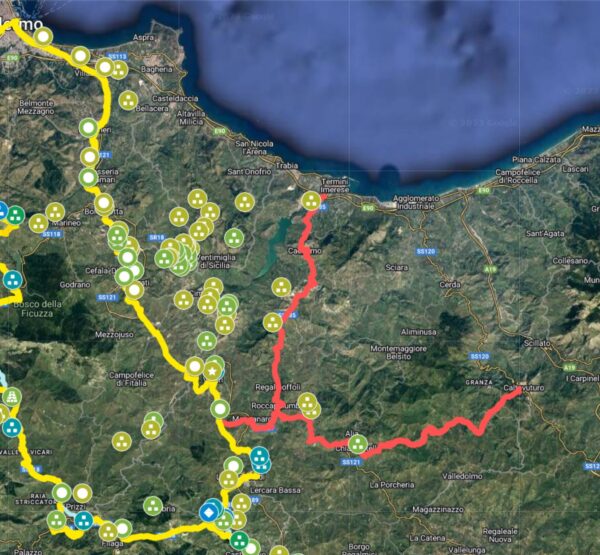
Probable Transversal IVT1 for Imera (Contrada La Catena – Alia – Caltavuturo) (3.482)
- IVT1.1: Contrada La Catena
- IVT1.2: Contrada Le Rocche (CAMS)
- IVT1.3: Contrada Barbarà (CAMS)
- IVT1.4: Caltavuturo (CAMS)
Probable VT2 cross road for Imera (Roccapalumba – Regalgioffoli – Termini Imerese) (18.334)
- IVT2.1: roccapalumba
- IVT2.2: Gift Gioffoli (18.334)
- IVT2.3: Termini Imerese (CAMS)
Insights
VAT Section (Agrigento – San Luca)

(C7) Sicily. Publisher: Robert Laurie & James Whittle - London (1799). Improved card taken from the card of Samuel von Schmettau from 1721.
Section IVB (San Luca – Palermo)
Section IVB1 (San Luca – Corleone – Palermo branch)

The blue track (to be explored) is shorter and would be the most direct route. In this phase, I preferred to pass the route so as to take into account the sites of Cozzo Bisagna (Greek settlement) and Contrada S. Elena (Greek and Roman settlement. Where in the future the route in blue should be privileged, it will still be necessary to take into account a cross that connects the route with these two sites. To underline the Contrada Zuccarone, a Roman miliarium was found, attributed to the consul Aulus Gellius and dated to 252 BC, in the midst of the First Punic War (18.334 ) (59) (64) (65) (66).
Section IVB2 (San Luca branch – Misilmeri – Palermo)
This stretch essentially derives from what was hypothesized by Biagio Pace (3.74) and from the many archaeological sites which would in any case suggest a route belonging to the Greco-Roman period. In red possible further cross roads for Imera.
Probable IVT1 Transversal for Imera (Contrada La Catena – Alia – Caltavuturo)
Probable VT2 cross road for Imera (Roccapalumba – Regalgioffoli – Termini Imerese)
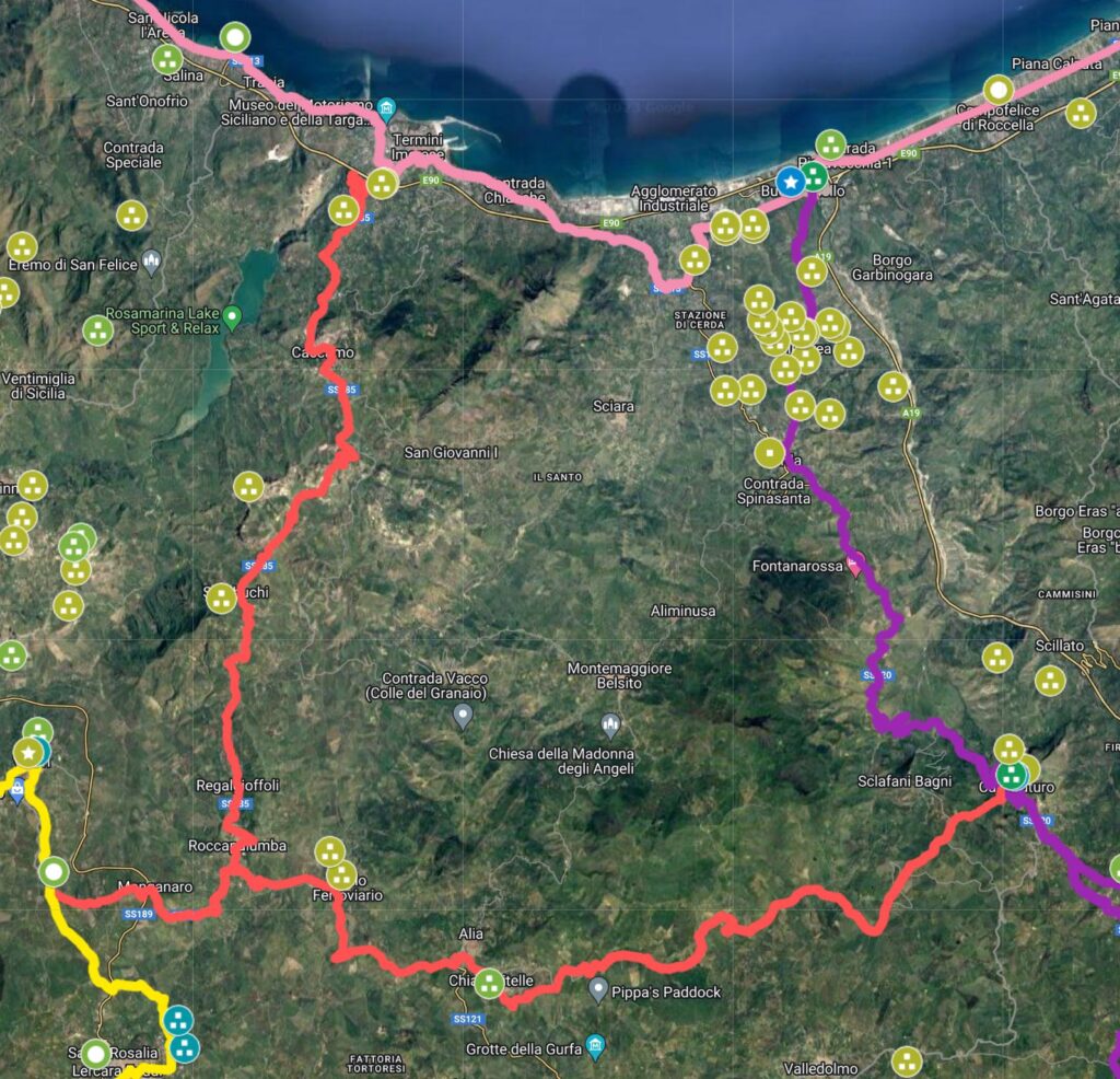
In the image in red the two possible transversal routes for Imera. In purple the Catania-Imera route and in orange, the Messina-Palermo route.
Bibliography and Reference Cartography.
(1) (3) (6) (13) (15) (17) (18) (22) (25) (36) (59) (64) (65) (66) (99) (CAMS) (C1) (C2) (C4) (C7) (C12) (C13) (C14) (C16) (C18) (C26) (C27) (C29) (C30)
- [1] Giovanni Uggeri: The formation of the Roman road system in Sicily
- [3] Biagio Pace: Art and Civilization of Ancient Sicily Vol. 1 pag. 453-488
- [6] Description of Sicily extracted from an Arabic book (re. Anas. 1764) by Al-Idrisi (Author), Nuccio Cannarella (Editor), Domenico Macrì (Translator) Published in 2019
- [13]: G. Uggeri: Itineraries and roads, routes, ports and ports of call of late ancient Sicilyin Proceedings IX Ancient Sicily Congress (Palermo 1997), "Kokalos" 43-44 (1997-1998), Rome 2000, pp. 299-364.
- [15]: G. Uggeri: The Roman road system in Sicily with particular regard to the third and fourth centuries. In Kokalos XXVIII-XXIX 1982-1983
- [17]: G. Uggeri: Sicily in the "Tabula Peutingeriana" - Editore Loffredo - Naples 1968
- [18]: G. Uggeri: Vancient and medieval viability. An example of persistence in the long term: The via Palermo - Agrigentoin Multicultural societies in the V-IX centuries(Acts VII days on the Romano-barbarian age, Benevento), edited by M. Rotili, Naples 2001, pp. 321-36.
- [22] Adolfo Holm History of Sicily Antiquity Vol. III Chap IV
- [25] From Renda to Palermo edited by: Maria Carmela Ferracane, Sandra Proto, Fabio Militello Sicilian Region 2013
- [36] Tommaso Fazello - History of Sicily Volume I. Palermo
- [59]: Angelo Vintaloro- "Atlas of the ancient road system of central-western Sicily" - Publisher Archeoclub Alto e Medio Belice Corleonese 2022
- [64]:Report by Chiara Michelini The milestone of Aurelius Cotta (ILLRP n. 1277): a plaque in context. © 2006 Scuola Normale Superiore Pisa
- [65] Superintendency for Cultural and Environmental Heritage of Palermo. Archeology the Inland Sites
- [66] Archaeological News of the Superintendence of Palermo 3/2016
- [99] Ignazio Caloggero: The Project Ancient Paths and Historical Itineraries of Sicily
- CAMS: Multimedia Archaeological Map of Sicily - Link: https://www.lasiciliainrete.it/archivio-patrimonio-archeologico-di-sicilia/
- C1: Road and rail communications - 1943 Author: Great Britain. Army. Royal Engineers. Field Survey Company, 514th.
- C2: Regni & Insvlae Siciliae Tabula geographica ex Archetypo gradiori in hoc compendium redacta - 1747 author: Homann, Johann Baptist
- C4: Nova et accurate Siciliae Regionum, Urbium, Castellorum, Pagorum Montium, Sylvarum, Planitierum, Viarum Situum ac Singularium quorumque locorum et rerum ad Geographiam Partinentium Descriptio Universalis - 1721 author Schmettau, Samuel von
- C7: Sicily. Publisher: Robert Laurie & James Whittle (1799) (always referable to the Schmettau paper)
- C12: Siciliae Antiquae quae et Sicania et Trinacria dicta tabula geographic. Publisher: L'Isle, Guillaume de, 1675-1726
- C13: [4] Tabula Peutingeriana (medieval map of the Roman world written by a monk of Colmar XIII century
- C14: [5] Itinerarium Antonini
- C16: Guidelines of the Regional Territorial Landscape Plan - Historic road network
- C18: Sicily Trazzerale Network (1929). Published in the Journal of the Land Registry and Tax Services in 1941
- C26: Europe in the XNUMXth century. century (with the Third Military Survey)
- C27: Comparative Map of Modern Sicily (1859)
- C29: La Sicile Pour l'Histoire Romaine (1740)
- C30: Cartography of the Landscape Plans of the Sicily Region which can be consulted online (for the trazzere and historical routes)
For the bibliography and general cartography see the page: Methodological Notes and Bibliography
Technical and methodological note
The Multimedia Map of the Ancient Historical Routes is created in two sub-phases (not necessarily sequential):
- Phase A (Basic Path): in the first sub-phase the paths are identified in the form of a first draft divided into segments and sections (taking into account the bibliography, the historical maps analyzed and the Multimedia Archaeological Map of Sicily (CAMS) and only partially the paths on the ground). The basic route is the starting point proposed to the scientific community, preparatory to the subsequent phase of detailed analysis of the individual segments that make up the entire identified path
- Phase B (Advanced Path): in the second phase, an incremental refinement process will begin by adapting, as faithfully as possible, the individual components that make up the route to the historical routes and to the tracks on the ground and where the ancient traces have been lost, adapt them to the current routes that are closest to the ancient paths (keeping track of the historical paths, where identified). The incremental refinement process will also take into account historical roads, natural roads and further studies and contributions from the scientific community and scholars in the sector.
- Phase C (Subdivision of the paths): When fully operational, the project provides for the drafting of two paths that may diverge in some points: a path as faithful as possible to the ancient path regardless of its current practicability and another that could form the basis for proposing itineraries that take into account the actual practicability and the possibility of enjoying the historical, artistic and naturalistic beauties close to the historical route.
Note: In cases where the ancient route is no longer identifiable or has been completely replaced by high-speed roads, or obstructed by industrial plants or other types of impediment, an attempt has been made to identify a stretch that in some way is closest to the characteristics of a naturalistic path or in any case a substitute for the fast-flowing path. In some cases, moreover, in case of doubt between two possible routes, the route that allows you to pass in the immediate vicinity of landscapes or cultural heritage considered interesting from a tourist-cultural point of view has been taken into consideration.
