

III. Via Catania – Agrigento
Phase B: Rev 1.0 (edited by Ignazio Caloggero)
Interactive map updated in real time. For a global view of all the historical itineraries of Sicily, for the presentation of the project, the "zoomable" historical maps taken as reference and the relative methodological notes, please refer to the project page: Ancient paths and historical itineraries of Sicily. For a view of all the routes in one web page, see: Ancient Paths and Historical Itineraries of Sicily: All the routes live. The map shows the main "stations" and the archaeological sites encountered along the way. Under the map further details and technical notes.
Note: in magenta, the probable Catania-Agrigento route, in purple, a possible variant via Palagonia. In red, possible traverses that may not necessarily be part of the main route. In light blue, possible variants still to be studied. On the map, to facilitate the vision of the shared sections, the route relative to the Via Selinuntina (Syracuse-Agrigento section) is also displayed (in blue).
Description
The Catania – Agrigento route indicated in the Itinerarium Antonini is probably one of the most difficult routes to reconstruct, one could hypothesize that a route has undergone some modifications with the addition of a new section compared to the older route (Philosophiana – Petiliana) (B. Pace 3.473). The two distinct layouts appear intact, even in an ancient map: Siciliae Antiquae quae et Sicania et Trinacria dicta tabula geographica (1714)
 Siciliae Antiquae quae et Sicania et Trinacria dicta tabula geographica (1714)
According to the Itinerarium Antonini we therefore have:
- Catania
- Capitonian
- Philosophiana (Gela sive Filosofianis) (Gelentium Philosophiana)
- Variant for Petiliana
- Petiliana (Delia?)
- Variant for Calloniana and Corconiana
- Calloniana (Caulonia)
- Corconian
- Agrigento
The difficulty that scholars have encountered is in not being able to indicate some stations with reasonable certainty, in particular the stations of Calloniana and Corconiana.
According to Pace (3.473), these two stations would be along the S. Cataldo, Serradifalco, Favara line, even if Pace himself is perplexed by this tour to the north, considering that Caltanissetta, in those days, should not have had such importance as to become a road junction.
According to Cluverio, quoted by Pace himself, Calloniana is to be equated with Pietraperzia but Pace does not agree on this. Holm (22.484) matches Calloniana with Ravanusa and Corconiana in the neighborhood of Naro. Furthermore, the limited quantity of archaeological traces of direct evidence of the ancient road network and at the same time, the high number of indirect archaeological evidence (settlements and traces of Greek and Roman presences), does not make it easy to identify a clear and unique route ( if ever there was). The result is that precisely the high number of Greek and Roman settlements suggests both paths that over time have adapted to different needs, and the presence of a large number of variants and transversals.
A further element that has been the cause of reflections among the various scholars is the location of Capitoniana identified in different places and in particular in Contrada Castellitto or in Contrada Favarotta‐Tenuta Grande. This has led to the tracing of two possible paths, one of which is colored in purple.
Summary of traits, sub-tracts and variants
- Section IIIA (Catania – Sophiana)
- Section IIIA1: (Catania – Castellito – Sophiana)
- Possible Variant IIIA2: (Catania – Palagonia – Sophiana)
- Section IIIB (Sophiana – Agrigento)
- Variant IIIB1: (Sophiana – Calloniana – Agrigento)
- Variant IIIB2: (Sophiana – Petiliana – Agrigento)
Transversal
-
- Transversal IIT1: Contrada Pietrarosssa – Portella del Gigliotto
- Transversal IIT2: Transversal Villa Romana del Casale – Contrada Balsi
- Transversal IIT3: Transversal Barrafranca – Caltanissetta
- Transversal IIIT4: Caltanissetta – Serradifalco – Cazzola transversal
detailed description
Section IIIA (Catania – Sophiana)
Section IIIA1: (Catania – Castellito – Sophiana)
- Catania (5) (4) (4.472-473) (31)
- Booklet (31.62) (CAMS)
- IIIA1.1: Giarretta dei Monks (CAMS) (C30) (3.472) (31.61) (C26)
- IIIA1.2: Goalkeeper (C30) (C26)
- IIIA1.3: Contrada Stimpato (CAMS) (C30)
- IIIA1.4: Contrada Castellito (Capitonian?) (5) (3.472) (22.484) (31.62) (CAMS)
- IIIA1.5: Poggio delle Forche (CAMS)
- IIIA1.6: Ramacca (31.69)
- IIIA1.7: Contrada Montagna (CAMS) (C26)
- IIIA1.8: Cozzo Santa Maria CAMS) (C26)
- IIIA1.9: Contrada Margherita Sottano (CAMS) (C26) (3.472)
- IIIA1.10: Contrada Margherita Soprano (CAMS) (C26) (3.472)
- IIIA1.11: Contrada Casalgimondo (CAMS) (C26)
- IIIA1.12: Contrada Pietrarossa (CAMS) (C26)
- IIIA1.13: Contrada Crunici (CAMS) (C26)
- IIIA1.14: Contrada Liota (CAMS)
- IIIA1.15: Feudonuovo Ditch (CAMS)
- IIIA1.16: Contrada Neggi (CAMS) (C26)
- IIIA1.17: Monte Molera (CAMS) (C26)
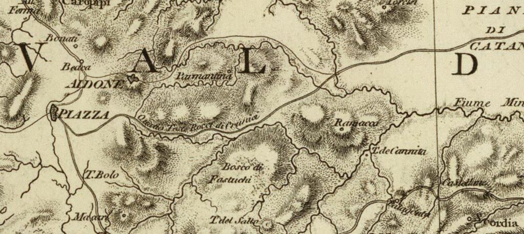
- IIIA1.18: Aidone (CAMS) (3.472) (C26)
- IIIA1.19: Montagnola (C26)
- IIIA1.20: Madonna of the Walnut (C26)
- IIIA1.21: Piazza Armerina (3.472) (C26)
- IIIA1.22: Monte Mangone (CMAS) (C26)
- IIIA1.23: Villa Romana del Casale (CAMS)
- IIIA1.24: Cockpit plan (C26) (C27)
- Philosophiana (Gela sive Filosofianis) (Gelasium Philosophiana) (5) (3.472) (22.484) (31.72)
Possible Variant IIIA2: (Catania – Palagonia – Sophiana)
- Catania (5) (4) (4.472-473) (31)
- Booklet (31.62) (CAMS)
- IIIA2.1: Contrada San Martino (C26)
- IIIA2.2: Torre di Stella pass (C30) (C26)
- IIIA2.3: Contrada Gelso (CAMS) (Ceuso: C26)
- IIIA2.4: Contrada Margia (Palagonia) (CAMS) (C4-C7) (C26) (C27) (C30) (C15)
- IIIA2.5: Contrada Annunziata (CAMS) (C26) (C27)
- IIIA2.6: Rocchichellaq (Palike) (CAMS) (C4) (C26)
- IIIA2.7: Favarotta Tenuta Grande (Capitonian?) (5) (2) (63) (31.62) (CAMS) (C4 but not C7) (C27) (C26) (C15)
- IIIA2.8: Contrada Faito (CAMS) (C26)
- IIIA2.9: Contrada Niscima (CAMS) (C30) (C26) (C15)
- IIIA2.10: Contrada Croce (CAMS) (C26) (C30)
- IIIA2.11: Contrada Maddalena (CAMS) (C30) (C26)
- IIIA2.12: Contrada Cappuccini (Caltagirone) (CAMS) (C26) (C27) (C4-C7) (C27)
- IIIA2.13: Monte San Giorgio (CAMS) (C26) (C27) (C30)
- IIIA2.14: Contrada Cappuccini (Caltagirone) (CAMS) (C26) (C27) (C30)
- IIIA2.15: Contrada Caldai (CAMS) (C26) (C27) (C30)
- IIIA2.16: San Michele di Ganzeria (CAMS) (C26) (C27) (C30) (C4-C7) (C27)
- IIIA2.17: Gigliotto (CAMS) (C30)
- Philosophiana (Gela sive Filosofianis) (Gelasium Philosophiana) (5) (3.472-473) (22.484) (31.72)
Stretch IIIB (Sophiana – Agrigento)
Variant IIIB1: (Sophiana – Calloniana – Agrigento)
-
- Philosophiana (Gela sive Filosofianis) (Gelasium Philosophiana) (5) (3.472-473) (22.484) (31.72)
- IIIB1.1: Mazarin (C26) (C30)
- IIIB1.2: Contrada Bartoli (C26) (C30)
- IIIB1.3: Contrada Schiette (C26) (C30)
- From Riesi to Agrigento I would make the route coincide with Syracuse Agrigento (see Variant VEa (Spinasanta – Niscemi – Agrigento)
- VEa.12: Riesi (3.476) (CAMS) (C30) (C26)
- VEa.13: Monte Bosco/Monte Oliveto/Serra Perciata (CAMS) (C30) (C26)
- VEa.14: Ravanusa (3.476) (CAMS) (C26) (C30) (Callonian?) (22.484) (C27)
- VEa.15: Monte Saraceno (C26) (CAMS) CAMS) (C30)
- VEa.16: Contrada Milici (C26) (CAMS) (C26) (C30)
- VEa.17: Campobello di Licata (99) (C27)
- VEa.18: Contrada Tre Fontane (CAMS) (C30)
- VEa.19: Case Schembari (CAMS) (C30)
- VEa.20: Castellazzo di Camastra (CAMS)
- VEa.21: Contrada Balate (CAMS)
- VEa.22: Contrada Canale (CAMS)
- VEa.23: Naro (3.476) (CAMS) (Corconian?) (22.484) (C27)
- VEa.24: Rocca Stefano (CAMS)
- VEa.25: Favara (3.476) (C27)
- Agrigento (S5) (3.475) (C13) (C14) (C30)
Variant IIIB2: (Sophiana – Petiliana – Agrigento)
- IIIB2.1: Cuddle lift (CAMS)
- IIIB2.2: Contrada Balsi (C26)
- IIIB2.3: Barrafranca (CAMS) (C26) (C7)
- IIIB2.4: Ippolito Fontanazza (CAMS) (C26)
- IIIB2.5: Case Vicario (CAMS) (31.84) (31 TABLE XLI) (C26)
- IIIB2.6: Masseria Arciero (CAMS) (31.84) (31 TABLE XLI) (C26)
- IIIB2.7: Sommatino (C27) (C26)
- IIIB2.8: Delia (Petilian?) (3.472) (22.484) (C27) (C26) (C7)
- IIIB2.9: St Philip (C26)
- IIIB2.10: Canicattì (C27) (C26) (C7)
- IIIB2.11: Serra Soldano (CAMS) (C26)
- IIIB2.12: Contrada Fondachello (C26) (C26)
- IIIB2.13: Castrofilippo (CAMS) (C26) (C27) (C7)
- IIIB2.14: Contrada San Gregorio (CAMS)
- IIIB2.15: Rocca Stefano (CAMS)
- IIIB2.16: Favara (3.472-473) (C27) (C7)
- Agrigento (5) (3.472-473) (C27) (C7)
Transversal IIT1: Contrada Pietrarosssa – Portella del Gigliotto
- IIT1.1: S. Maria La Mattina estate (CAMS)
- IIIT1.2: Contrada Fargione (CAMS)
- IIIT1.3: Borgo Baccarato (CAMS)
- IIIT1.4: Contrada Dragofosso (CAMS)
- IIIT1.5: Contrada Gallinica (CAMS)
- IIIT1.6: Mirabella Imbaccari (31.62)
- IIIT1.7: Gigliotto (CAMS) (C26)
Transversal IIT2: Transversal Villa Romana del Casale – Contrada Balsi
- IIT2.1: Roman Villa of Casale
- IIIIT2.2: Contrada Rossignolo (CAMS) (C26)
- IIIT2.3: Mount Navone (CAMS) (C26)
- IIIT2.4: Contrada Scalisa ((C26)
- IIIT2.5: Navonello houses (Contrada Balsi) (C26)
Transversal IIT3: Transversal Barrafranca – Caltanissetta
- IIIT3.1: Contrada Setica (Siddica)
- IIT3.2: Contrada Albana (CMAS) (C30) (C26)
- IIIT3.3: Town of the Valley (CAMS) (C26)
- IIIIT3.4: Perziastone (C26)
- IIIT3.5: Rancito (CAMS)
- IIIT3.6: Rocche Parcazzo (CAMS) (C26)
- IIIT3.7: Gibil Gabib (CAMS)
- Caltanissetta (CAMS) (C26)
Transversal IIIT4: Caltanissetta – Serradifalco – Cazzola transversal
- IIT4.1: Contrada Palmitelli (CAMS) (C30)
- IIIIT4.2: San Cataldo (3.472-473) (C30)
- IIIT4.3: Vassalage
- IIT4.4: Serradifalco (3.472-473)
- IIIT4.5: Contrada Perciata
- IIIT4.6: Casa Cazzola
- IIT4.7: Serra Soldano (Corconian?)
Insights
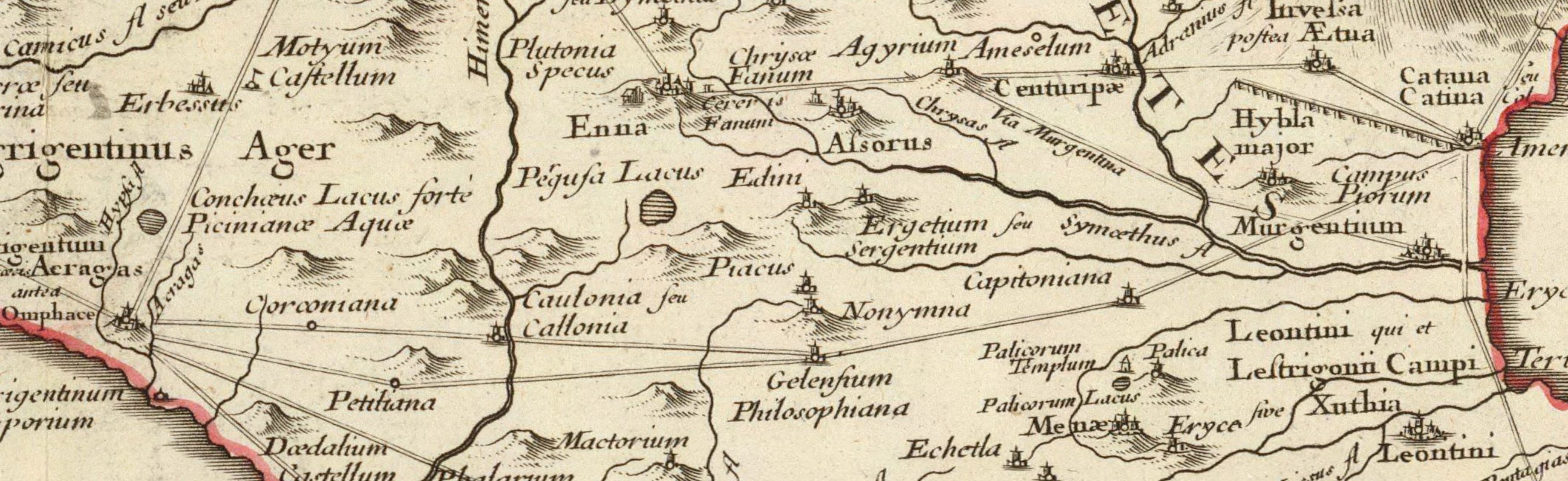
C2: Siciliae Antiquae quae et Sicania et Trinacria dicta tabula geographica (1714)
Section IIIA (Catania – Sophiana)
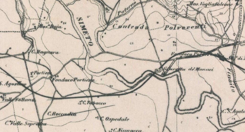
C26: Giarretta dei Monaci – Goalkeeper
C4-C7 (Castellito – Margherito below)
Possible Variant IIIA2: (Catania – Palagonia – Sophiana)

C27: Comparative Map of Modern Sicily (1859 (From Simeto to Caltagirone)
Bibliography and Reference Cartography.
(1) (2) (3) (13) (15) (19) (22) (27) (31) (36) (37) (38) (60) (63) (99) (CAMS) (C2 ) (C4) (C7) (C12) (C13) (C14) (C15A) (C16) (C17) (C18) (C20) (C26) (C27) /C28) (C29) (C30)
- [1] Giovanni Uggeri: The formation of the Roman road system in Sicily
- [2] Elisa Bonacini: A proposal for identification along the Via A Catina - Agrigento in AITNA - Quaderni di Topografia Antica - 4 - Sicilian Center of Ancient Topography
- [3] Biagio Pace: Art and Civilization of Ancient Sicily Vol. 1 pag. 453-488
- [13]: G. Uggeri: Itineraries and roads, routes, ports and ports of call of late ancient Sicilyin Proceedings IX Ancient Sicily Congress (Palermo 1997), "Kokalos" 43-44 (1997-1998), Rome 2000, pp. 299-364.
- [15]: G. Uggeri: The Roman road system in Sicily with particular regard to the third and fourth centuries. In Kokalos XXVIII-XXIX 1982-1983
- [19]: Proceedings of the Conference L'antica Petiliana in the Itinerarium Antonini Delia (CL) 6 September 2014 by Luigi Santagati and Paolo Busub - Nissen Society of Homeland History - Scarabelliana Series n. 24
- [22] Adolfo Holm History of Sicily Antiquity Vol. III Chap IV
- [27] Marco Sfacteria: Roman roads in Sicily. New observations on the hypothetical route of the internal Catania-Agrigento route - P e lo ro I magazine, 1 - 2016
- [31] Mansionibus nunc institutis (It. Ant. 94,2). Marco Sfacteria Research Doctorate (It. Ant. 94,2). 2016 + [31B] Associated tables
- [36] Tommaso Fazello - History of Sicily Volume I. Palermo
- [37] Topographical Dictionary of Sicily by Vito Amico - translated by Gioacchini di Marzo Vol. 1 - Palermo 1855
- [38] Topographical Dictionary of Sicily by Vito Amico - translated by Gioacchini di Marzo Vol. 2 - Palermo 1859
- [63]: Elisa Bonacini: Capitoniana in Contrada Favarotta – Tenuta Grande? In Valdinoto Magazine of the Calatina Society of Homeland History and Culture 1/2006
- [99] Ignazio Caloggero: The Project Ancient Paths and Historical Itineraries of Sicily
- CAMS: Multimedia Archaeological Map of Sicily - Link: https://www.lasiciliainrete.it/archivio-patrimonio-archeologico-di-sicilia/
- C2: Regni & Insvlae Siciliae Tabula geographica ex Archetypo gradiori in hoc compendium redacta - 1747 author: Homann, Johann Baptist
- C4: Nova et accurate Siciliae Regionum, Urbium, Castellorum, Pagorum Montium, Sylvarum, Planitierum, Viarum Situum ac Singularium quorumque locorum et rerum ad Geographiam Partinentium Descriptio Universalis - 1721 author Schmettau, Samuel von
- C7: Sicily. Publisher: Robert Laurie & James Whittle (1799) (always referable to the Schmettau paper)
- C12: Siciliae Antiquae quae et Sicania et Trinacria dicta tabula geographic. Publisher: L'Isle, Guillaume de, 1675-1726
- C13: [4] Tabula Peutingeriana (medieval map of the Roman world written by a monk of Colmar XIII century
- C14: [5] Itinerarium Antonini
- C15A: General Map of the Island of Sicily - Officio Topografico 1826 (South-East)
- C16: Guidelines of the Regional Territorial Landscape Plan - Historic road network
- C17: Syracuse at the time of Gelone and Gelone I map with the roads leaving Syracuse attached to the book by Adolfo Holm: Storia di Sicilia-Vol. THE
- C18: Sicily Trazzerale Network (1929). Published in the Journal of the Land Registry and Tax Services in 1941
- C20: The island of Sicily divided into its valleys. Chamber chalcography (1792) (Rome, Italy) - Author: Ram, de Johannes 1648-1693
- C26: Europe in the XNUMXth century. century (with the Third Military Survey)
- C27: Comparative Map of Modern Sicily (1859)
- C28: Siciliae Antiquae Tabula (1834) (Sicily Tabulae Peutingerianae)
- C29: La Sicile Pour l'Histoire Romaine (1740)
- C30: Cartography of the Landscape Plans of the Sicily Region which can be consulted online (for the trazzere and historical routes)
For the bibliography and general cartography see the page: Methodological Notes and Bibliography
Technical and methodological note
The Multimedia Map of the Ancient Historical Routes is created in two sub-phases (not necessarily sequential):
- Phase A (Basic Path): in the first sub-phase the paths are identified in the form of a first draft divided into segments and sections (taking into account the bibliography, the historical maps analyzed and the Multimedia Archaeological Map of Sicily (CAMS) and only partially the paths on the ground). The basic route is the starting point proposed to the scientific community, preparatory to the subsequent phase of detailed analysis of the individual segments that make up the entire identified path
- Phase B (Advanced Path): in the second phase, an incremental refinement process will begin by adapting, as faithfully as possible, the individual components that make up the route to the historical routes and to the tracks on the ground and where the ancient traces have been lost, adapt them to the current routes that are closest to the ancient paths (keeping track of the historical paths, where identified). The incremental refinement process will also take into account historical roads, natural roads and further studies and contributions from the scientific community and scholars in the sector.
- Phase C (Subdivision of the paths): When fully operational, the project provides for the drafting of two paths that may diverge in some points: a path as faithful as possible to the ancient path regardless of its current practicability and another that could form the basis for proposing itineraries that take into account the actual practicability and the possibility of enjoying the historical, artistic and naturalistic beauties close to the historical route.
Note: In cases where the ancient route is no longer identifiable or has been completely replaced by high-speed roads, or obstructed by industrial plants or other types of impediment, an attempt has been made to identify a stretch that in some way is closest to the characteristics of a naturalistic path or in any case a substitute for the fast-flowing path. In some cases, moreover, in case of doubt between two possible routes, the route that allows you to pass in the immediate vicinity of landscapes or cultural heritage considered interesting from a tourist-cultural point of view has been taken into consideration.
