

Ancient Paths and Historical Itineraries of Sicily: XI Trasversali Sud Est
Sicule, Greek, Roman and Byzantine Paths and Transversals of the South East
PRESS RELEASE: THIS AREA WILL SEE THE ROUTES EASY TO BE REDUCE AS THE PAGE WILL BE REPLACED.
Phase B.1.1 (edited by Ignazio Caloggero)
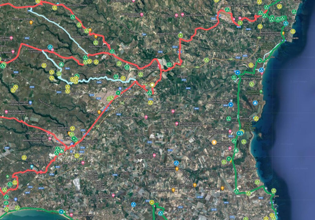
Interactive map updated in real time. For a global view of all the historical itineraries of Sicily, for the presentation of the project, the "zoomable" historical maps taken as reference and the relative methodological notes, please refer to the project page: Ancient paths and historical itineraries of Sicily. For a view of all the routes in one web page, see: Ancient Paths and Historical Itineraries of Sicily: All the routes live.
The map shows the main "stations" and the archaeological sites encountered along the way. Under the map further details and technical notes. In order to allow a global view, the routes relating to the following routes are also shown: Catania – Agrigento, Via Selinuntina and the Maritima Loca (Syracuse-Agrigento sections
Synthesis of the Transversals
- T1: Transversal Cava Palumbo – La Marchesa (Noto)
- T2: Gulfi – Ragusa cross road
- T3: Cross Poggio del Monaco Licata
- T4: Transversal Acate – Maritima Loca
- T5: Transversal Ragusa – Maritima Loca
- T5A: Transversal Ragusa – Kamarina via Donnafugata
- T5B: Transversal Ragusa – Kamarina via Grotte delle TrabacChe
- T5C: Transversal Ragusa – Marina di Ragusa/Santa Croce Camerina
- T6: Transversal Ragusa – Pozzallo/Ispica
- T7: Transversal Modica – Rosolini
- T7A: Modica – Bonfalà cross road
- T7B: Transversal Modica – Contrada Gisira
- T7C: Transversal Contrada Cannicarao – Contrada Zacchitta
- T8: Palazzolo Acreide – Noto transversal road
- T9: Transversal Ragusa – San Giacomo – Palazzolo Acreide
- T10: Palazzolo Acreide – Cassibile cross road
- T11: Aguglia – Castelluccio
- T12: Transversal Camarina – Chiaramonte Gulfi
- T13: Transversal Palazzolo Acreide – Bonfalà (Rosolini)
- T14: Transversal Passoladro/Manghisi – Contrada Nicastro
- T15: Transversal Avola – Pozzallo
- T16: Transversal Via Selinuntina – Catania/Agrigento
Note: the T16 corresponds to the Trasversale XIII of the old numbering
Below is the detailed description
T1: Cava Palumbo – La Marchesa (Noto)

- T1.1: Red Fountain (C26) (C30 (CAMS)
- T1.2: Messina Houses (C26) (C30 (CAMS)
- T1.3: Three Chestnuts (C26) (C30 (CAMS)
- T1.4: San Corrado di Fuori (C26) (C30)
- T1.5: The Marquise (Noto) (C26) (C30
T2: Transversal (Gulfi – Ragusa) (VCa/VCb)
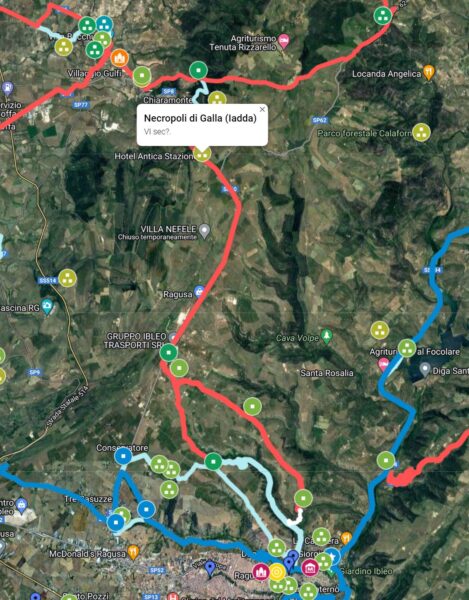
- T2.1: Necropolis of Galla (Iadda)
- T2.2: Contrada Serra di Corna (C26) (C30 (C27)
- T2.3: Contrada Torrazza (C26) (C30
- T2.4: Possible variant: Torrazza – Contrada Cilone/Contrada Prato (C26) (C30
- T2.5: Possible variant: Torrazza – Contrada Cornocchia – Casa Chiaramiri (C26) (C30
- Hybla (C26) (C30
T3: Transversal Monte Priorato/Poggio del Monaco – Licata

- T3.1: Monte Priorato (CAMS)
- T3.2: Milingiana (CAMS)
- T3.3: Gurgazzi (CAMS)
- T3.4: Sister Marchesa (CAMS)
- T3.5: Ficuzza (CAMS)
- T3.6: Contrada Calì (CAMS)
- T3.7: Poggio Marcato D'Agnone (CAMS)
- T3.8: Contrada Casalicchio – Contrada Coltello (CAMS)
- Licata
T4: Transversal (Acate – Maritima Loca)

- T4A.1: Large Patch (CAMS) (C30)
- T4A.2: Contrada Casale (CAMS) (C30)
- T4A.3: Cozzo Cicirello (CAMS) (C30)
- T4A.4: Brat (CAMS) (C30)
- T4A.5: Pezzalagno (CAMS) (C30)
- T4A.6: Ascent Shaft (99) (C30)
in Pozzo Salita reunification with the Maritima Loca
T5: Transversal bundle (Ragusa – Maritima Loca)
T5A: Transversal Ragusa – Kamarina via Donnafugata
From Ibla to Cisternazzi same route as Via Selinuntina
- T5A.1: Cisternazzi (C30) (C26) (CAMS)
- T5A.2: Gilestra II (C30) (C26)
- T5A.3: Donnafugata (C30) (C26) (CAMS) (possible connection with T5B)
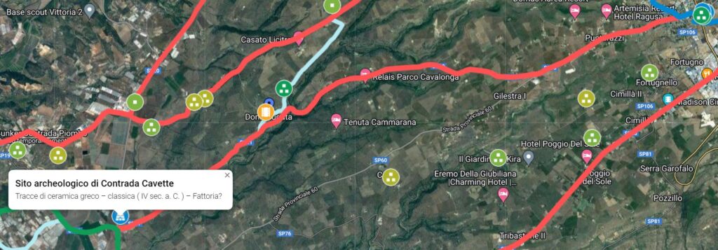
- T5A.4: Contrada Cavette (C30) (C26) (CAMS)
From Contrada Cavette up to Kamarina it follows the Maritima Loca
T5B: Transversal Ragusa – Kamarina via Grotte delle Trabache

From Ragusa to Grotte delle Trabacche (nearby) it follows the route of the via Selinuntina
- T5B.1: Grotta delloe Trabacche (nearby) (C30) (CAMS)
- T5B.2: Contrada Mangiapane (C30)
- T5B.3: Contrada Passolato (Passolatello) (C30) (CAMS)
In Contrada Passolato up to Kamarina the same route as the transversal – Kamarina – Chiaramonte Gulfi
T5C: Transversal Ragusa – Marina di Ragusa/Santa Croce Camerina

- T5C.1: Contrada Monaco C30) (C26)
- T5C.2: Warehouses C30) (C26)
- T5C.3: Contrada Pianicella C30) (C26)
- T5Ca Branch for S. Croce Camerina
- T5Ca.1: Contrada Muraglie C30) (C26) /CAMS)
- In Contrada Marchesa the path connects with the Via Maritima Loca
- T5Cb Branch for Marina di Ragusa
- T5Cb.1: Raven Cat C30) (C26)
- T5Cb.2: Contrada Nave C30) (C26)
- In Contrada Nave the path connects with the Via Maritima Loca
T6: Transversal Ragusa – Pozzallo/ Ispica

From Ibla to Contrada Giurgintano same route as Via Selinuntina
- T6.1: Contrada Giurgintano (CAMS) (C30 (C26)
- T6.2: Contrada Nicastro (C30 (C26)
- T6.3: Contrada S. Antonio (C30 (C26) (CAMS)
- T6.4: Devil's Coast (C30 (C26)
- T6.5: Chickpea Plan (C30 (C26)
- T6.6: St. Joseph Timpuni
- Modica
- Contrada Monserrato (C26) (CAMS)
- Contrada Tripods (C26) (CAMS)
- Michelica – Palazzetti (C26) (CAMS)
- Michelica (C26) (CAMS)
- Contrada Busta (C26)
- Variant for Pozzallo (Via Contrada Gisana and Bosco Piasana)
- Variant for Ispica
T7: Transversal Modica – Rosolini
T7A: Modica – Bonfalà cross road
- Modica
- T7A.1: Santa Venera (CAMS) (C30) (C26)
- T7A.2: Contrada Mista (CAMS) (C30) (C26)
- T7A.3: Contrada Catanzarello (C30) (C26)
- T7A.4: Contrada Bosco (CAMS) (C30) (C26)
- T7A.5: Onion (CAMS) (C30) (C26)
- T7A.6: Contrada Cassero (CAMS) (C30) (C26)
- T7A.7: Favarottella (CAMS) (C30) (C26) (see note T7A.7)
- T7A.8: Prainito Quarry (CAMS) (C30) (C26)
- T7A.9: Contrada Gisira (CAMS) (C30) (C26)
- T7A.10: Candelaro quarry
- T7A.11: Bonfalà – Passo di Miele
Here it rejoins the Avola – Pozzallo crossroads
T7B: Transversal Modica – Contrada Gisira
Up to Contrada Catanzarello same stretch of T7A
- Contrada Catanzarello
- T7B.1: Serrapero (CAMS) (C30) (C26)
- T7B.2: Contrada Zaccaria (Cava d'Ispica North) (CAMS) (C30) (C26)
- T7B.3: Superior Command (CAMS) (C30) (C26)
- T7B.4: Contrada Cannicarao (Cammararo in Capo) (see note T7B.4) (CAMS) (C30) (C26)
- T7B.5: Late Roman settlement of Torre di Commaldo (CAMS) (C30) (C26)
- T7B.6: Scalarangial Houses (CAMS) (C30) (C26)
- Contrada Gisira (CAMS) (C30) (C26)
From Contrada Gisira to Bonfalà same route as T7A
T7C: Transversal Contrada Cannicarao – Contrada Zacchitta
From Modica to Contrada Cannicarao same route as T7B
- Contrada Cannicarao
- T7C.1: Contrada Carbonella (CAMS) (C30) (C26)
- T7C.2: Quarry Marchesa (CAMS) (C30) (C26)
- T7C.3: Cozzo Cisterna (CAMS) (C30) (C26)
- T7C.4: Contrada Granati Vecchi (CAMS) (C30) (C26)
- T7C.5: Contrada Zacchitta (C30)
in Contrada Zacchitta the route rejoins the T12: Trasversale Avola – Pozzallo
T8: Palazzolo Acreide – Noto transversal road

From Palazzolo Acreide to just before Santa Lucia di Mendola, the route coincides with a stretch of the Via Selinuntina
- T8.1: Saint Lucia of Mendola (CAMS) (C30) (C26)
- T8.2: Contrada Aguglia (CAMS) (C30) (C26)
- T8.3: Deddera (CAMS) (C30) (C26)
- T8.4: Half Gregory (CAMS) (C30) (C26)
- T8.5: Head of Water (C30) (C26)
- T8.6: Butterfly (CAMS) (C30) (C26)
- T8.7: Netum (Noto Antica) (CAMS) (C30)
- T8.8: Buffatelli (CAMS) (C30)
From Buffatelli the route joins the T12: Trasversale Avola – Pozzallo
T9: Transversal Ragusa – San Giacomo – Palazzolo Acreide
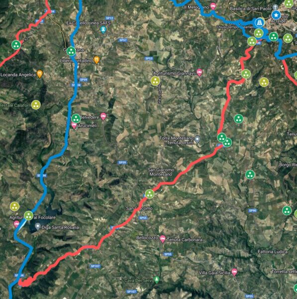
From Ibla to Contrada San Filippo it coincides with the Via Selinuntina
- T8.1: Contrada San Filippo (C30)
- T8.2: Buttress of the Forks (C30) (CAMS)
- T8.3: Contrada Marchesa (C30)
- Contrada Furmica (CAMS)
From Contrada Furmica onwards correspondence with the transversal T13: Trasversale Palazzolo Acreide
T10: Palazzolo Acreide – Cassibile cross road
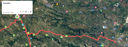
From Palazzolo Acreide to Passoladro same route as Via Selinuntina
- T10.1: Passoladro (CAMS) (C30)
- T10.2: Mangosi (CAMS) (C30)
- T10.3: Putrisino Quarry (CAMS) (C30)
- T10.4: Palumbo Quarry (CAMS) (C30)
- T10.5: Petracca Quarry (CAMS) (C30)
- T10.6: Stallaini – Cava Grande (CAMS) (C30)
- T10.7: Lawsuit (CAMS) (C30)
Cassibile
In Cassibile the route joins the Via Maritima Loca
T11: Transversal Aguglia – Castelluccio
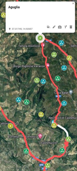
Up to Aguglia the route coincides with the T8
- T11.1: Sparano – Case Italia (CAMS) (C30)
- T11.2: Half Gregory (CAMS) (C30)
- T11.3: Castelluccio (CAMS) (C30)
- T11.4: Vallone Sermitella (CAMS) (note from Castelluccio to Sermitella, the route is still to be traced)
- T11.5: Castelluccio – Warren (CAMS)
- Salonia
from Salonia onwards correspondence with the transversal T13.
T12: Transversal Camarina – Chiaramonte Gulfi
This transversal, mentioned by B. Pace (3.482 and partly in 26.266) connects via Maritima Loca (VI) with Selinuntina (V).
Section T12.A (Camarina – Comiso)

-
- T12A.1: Port of Camarina (3.482) (C30) (C26)
- T12A.2 Grotta Re Cucco (near) (C30) (C26) (VI: Maritima Loca)
- T12A.3 Bunker Contrada Piombo (C30) (C26) (CAMS)
- T12A.4 Contrada Passolato (C30) (C26) (CAMS)
- T12A.5 Contrada Targena – Muraglia (C30) (C26)(CAMS)
- T12A.6 Barco (C30) (C26) (CAMS)
- T12A.7 Source Diana (Comiso) (3.482) (CAMS)
Section T12.B (Comiso – Gulfi)
-
- T12B.1: Merlin (CAMS)
- T12B.2: Margi – Defense (C30) (C26)(CAMS)
- T12B.3: Billona/Bosco Rotondo and Bosco Comitini (C30) (C26)(CAMS)
- T12B.4: Contrada Serra Carcara - Favaragghi
- T12B.5: Cifali (3.482) (C30) (C26)(CAMS)
- T12B.6: Contrada San Nicola
- T12B.7: Archaeological site of Aranci-Marana-Piano Conte (Akrillai) (3.482)
- From here branch off to Akray following the Via Selinuntina
From here branch for Licodia (Transversal Via Selinuntina / Catania Agrigento)
Note T12B.1 Possible Variants
Note T12B.2 Possible original section of the airport runway
T13: Transversal Palazzolo Acreide – Bonfalà (Rosolini)

The initial section coincides with via Selinuntina
- T13.1: Bibbinello (CAMS) (C30) (C26)
- T13.2: Contrada Poi (CAMS) (C30) (C26)
- T13.3: Contrada Furmica (CAMS) (C30) (C26)
- T13.4: Furmica – Benesiti (CAMS) (C30) (C26)
- T13.5: Cozzo Perciata Stone (C30) (C26)
- T13.6: Cozzo Sisca – Cozzo Vigna (CAMS) (C30) (C26)
- T13.7: Salonia (CAMS) (C30) (C26)
- T13.8: Bonfalà (CAMS) (C30) (C26)
T14: Transversal Passoladro/Manghisi – Contrada Nicastro
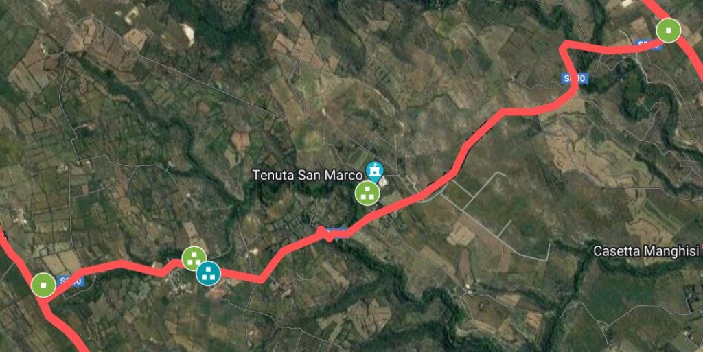
- T14.1: Passoladro/Manghisi
- T14.2: Contrada San Marco
- T14.3: Mulberry
- T14.4: Contrada Nicastro
T15: Transversal Avola – Pozzallo
From Avola to Contrada Puzzi same route as the Via Maritima Loca
- Contrada Puzzi (CAMS) (C30) (C26)
- Contrada San Giacomo (CAMS) (C30) (C26)
- Known (CAMS) (C30) (C26)
- St. Philip (CAMS) (C30) (C26)
- Bonfalà – Passo di Miele (CAMS) (C30) (C26)
- Contrada Zacchitta (C26)
- Narbalata (CAMS) (C30) (C26)
- Rosolini (CAMS) (C30) (C26)
- Contrada Rizzatolli (CAMS) (C30) (C26)
- San Giovanni (Ispica) (CAMS) (C30) (C26)
- Quarry Martella (CAMS) (C30) (C26)
- Bosco Pisana (CAMS) (C30) (C26)
- Carpintera (CAMS) (C30) (C26)
- Toll booth (CAMS) (C30) (C26)
- Pozzallo (CAMS) (C30) (C26)
T16: Transversal Via Selinuntina – Catania/Agrigento
This transversal, mentioned by B. Pace (3.482), connects via Selinuntina (V) with Catania / Agrigento (III).
Section T16A (SS 385 – Licodia)
-
- XIII.1 Contrada Santa Croce (C26)
- XIII.2 Cross Plan (CAMS)
- XIII.3 Grammichele (3.483) (C16)
- XIII.4 Contrada Fontanazza (or Fontranuzza) (C16) (C26) (C30) (see note 16A1)
- XIII.5 Mangalavite (C26) (C30) (C16)
- XIII.6 Bonferrat (C26) (C30) (C16)
- XIII.7 Contrada Pirrone (CAMS) (C16)
- XIII.8 Licodia (CAMS) (C16)
Section T16B (Licodia – Gulfi)
-
- XIII.1 Contrada San Filippo (CAMS)
- XIII.2 Sarpellizza - Bianchette (CAMS)
- XIII.3 Scifazzo (CAMS) (C26) (see note 16B1)
- XIII.4 Dirillo River (C26)
- XIIIA.5 Filo Zingaro Pass (3.482) (C26) (C30) (C16)
- XIII.6 Contrada Fegotto (C26) (C30)
- XIIIA.7 Gulfi (Acrilla) (3.482) (C30) (C16)
Section T16C (Licodia – Palazzolo Acreide)
- XIIIC.1 Contrada Santa Venere (C26) (C30) (C16)
- XIIIC.2 Our Lady of Petraro (C26) (C30) (C16)
- XIIIC.3 Vizzini (CAMS) (C26)
- XIIIC.4 Scifo trough (C30)
- XIIIC.5 Contrada Poggio del Lago (C30) C26)
- XIIIC.6 Contrada Spedalazzo (C30) (C26)
- XIIIC.7 Buccheri (CAMS) (C26)
- XIIIC.8 Monte Pavone (C26) (C30) (CAMS)
- XIIIC.9 Buscemi (C26) (C30)
- XIIIC.10 Our Lady of the Woods (C26) (C30) (CAMS)
- XIIIC.11 San Salvatore (C26) (C30) (CAMS)
- XIIIC.12 Former Palazzolo Station – Buscemi (C26) (C30)
From the former Palazzolo – Buscemi station up to Palazzolo Acreide it follows the Catania – Agrigento (III)
Section T16D.D (Licodia – Torrevecchia)
- XIIID.1 Fossa Quadara (C26) (C30 – up to Fossa Quadara) (CAMS)
- XIIID.2 Casasia (CAMS)
- XIIID.3 Canalicchio (C26) (C30 – from Canalicchio onwards)
- XIIID.4 Contrada Cugni (C26) (C30)
- XIIID.5 Contrada Canalazzo (C26) (C30)
- XIIID.6 Alia (CAMS) (C26) (C30)
- XIIID.7 Monterosso Almo (C26) (C30)
- XIIID.8 Contrada Minchiuffo (C26) (C30)
From here on, the Catania – Agrigento (III) route follows, the section from Licodia Eubea to Fontanazza to be considered closest to the historic route is the one other than red. In fact, this section corresponds to the historical route indicated in C30 and is also present in the road system indicated in C26
Section T16E (Vizzini – Monterosso Almo)
- XIIIE.1 Contrada Casaletto/Poggio dei Santi (C26) (C30) (see note Note 13E1)
- XIIIE.1 Amerillo (C26) (C30)
From Amerillo to Alia and then Monterosso Almo same route as XIIID (5-6)
Insights
T7A: Modica – Bonfalà cross road
note T7A.7
Learn more in one of the future updates on the stretch from Contrada Favarottella, passing through Serrusco and Cammaratini, up to Contrada Gisira. The stretch is affected by historic roads (C30).
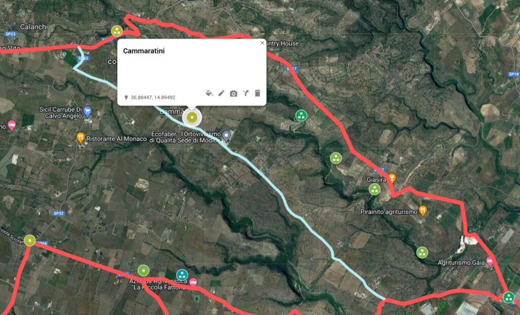

C30: Outlined the stretch of historic road network - https://www.sitr.regione.sicilia.it/geoportale/it/Home/GeoViewer?resourceLocatorId=1613
T7B: Transversal Modica – Contrada Gisira
Note T7B.4
 C26: Europe in the XNUMXth century. century (with the Third Military Survey)
Section T12.A (Camarina Comiso)
Note by Biagio Pace (26.266): Along the first stretch, with the exception of small variations, this road coincides with the old Comiso-S. Silvestro-Cammarana, the only artery existing in that stretch up to half a century ago, and the only one marked on the first card at 50 (f. 256, IX)
 Camarina - Comiso: Viability in the 26th century (CXNUMX)
Section T12.B (Comiso Gulfi)
Note T12B.1 Possible Variants: I have hypothesized three possible alternative routes which go from Comiso to Cifali
Note T12B.2 In the stretch from Contrada Serra Carcara – Favaragghi to the archaeological site of Cifali-Casa Ferreri it is probable that the original road cut the runway (at the end) (see line with different colour) of the current airport.
Note T12B.3 : The Comiso - Cannicarao stretch would be indicated by Biagio Pace (3.482) but it is not, in this revision, included in the route I have elaborated, as the sections I have chosen in this phase are those with the highest concentration of Greek and Roman remains . To include this site as well, it would be necessary to think of a further alternative route from Comiso to Cannicarao (trazzera fondo Cannicarao? - see also C30) and from Cannicarao to Gulfi.
Tract T16
Section T16A
Note 16A1:
Section T16B
Note 16B1: A possible hypothesis could be that the original section that from the Dirillo river to Scifazzo was partly occupied by the current Dirillo lake (see below section "T16A.4 - T16A.5" colored differently) This stroke is in fact present in the map (C26).
Tract T16D
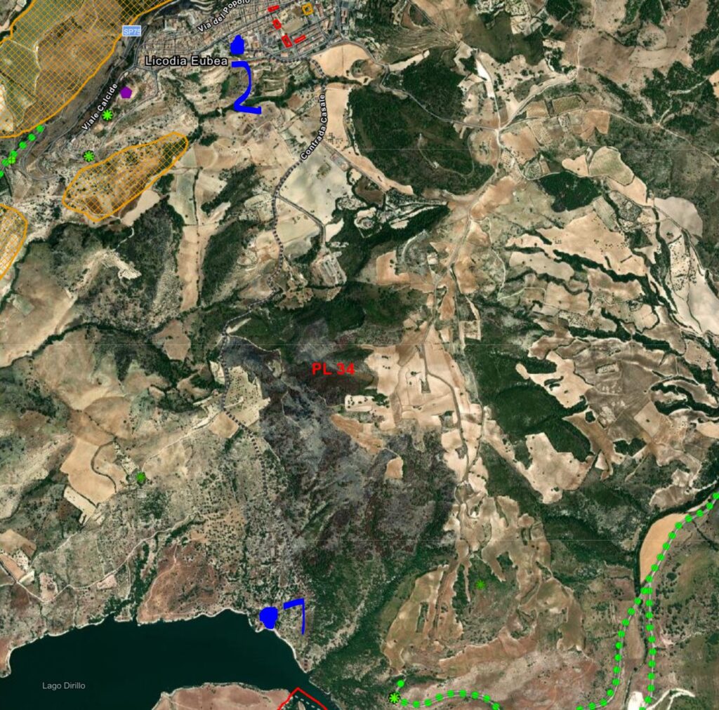
Licodia – Lago Dirillo section, historic route on the C30
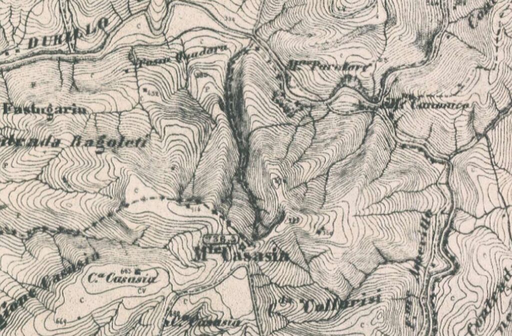
Fossa Quadara – Casasia stretch on C26
Section T16E
Note 16E1: In the section that starts from Contrada Casaletto/Poggio dei Santi it is probable that the original route differs in part (line not colored in red). In this regard, see the historical layout indicated in C30.
Bibliography and Reference Cartography.
(1) (3) (11) (13) (14) (15) (17) (22) (26) (29) (35) (36) (40) (42) (99) (CAMS) (C4 ) (C7) (C12) (C13) (C15A) (C16) (C17) (C18) (C26) (C27) (C29) (C30)
- [1] Giovanni Uggeri: The formation of the Roman road system in Sicily
- [3] Biagio Pace: Art and Civilization of Ancient Sicily Vol. 1 pag. 453-488
- [11]: Patitucci - G. Uggeri, Contribution to Tabula Imperii Byzantini of Sicily: the Ippari Valley, in SAMI, Proceedings VII Congr. Nat. arch. Med. (Lecce 2015), Florence 2015, pp. 436-41.
- [13]: G. Uggeri: Itineraries and roads, routes, ports and ports of call of late ancient Sicilyin Proceedings IX Ancient Sicily Congress (Palermo 1997), "Kokalos" 43-44 (1997-1998), Rome 2000, pp. 299-364.
- [14]: The Roman road system in Sicily and the medieval remains. Extract from: ROCK SICILY IN THE CONTEXT OF MEDITERRANEAN CIVILIZATIONS Proceedings of the sixth International Study Conference on Medieval Rock Civilization in Southern Italy (Catania - Pantalica - lspica, 7-12 September 1981) - Congedo Editore Galatina - 1986
- [15]: G. Uggeri: The Roman road system in Sicily with particular regard to the third and fourth centuries. In Kokalos XXVIII-XXIX 1982-1983
- [17]: G. Uggeri: Sicily in the "Tabula Peutingeriana" - Editore Loffredo - Naples 1968
- [22] Adolfo Holm History of Sicily Antiquity Vol. III Chap IV
- [26] Biagio Pace: The most recent excavations of Camarina in the Historical Archive for Eastern Sicily Year XIV - File I, II, II (1917)
- [29]: Corrado Fianchino, Gaetano Sciuto: The paths of naturalness in the south-east of Sicily - Aracne Edittrice - 2017
- [35] Francesca Buscemi: Ancient routes and modern travelers through the Iblei. Notes on historical topography in: Archaeological landscapes of south-eastern Sicily. Rosolini's landscape curated by Francesca Buscemi and Francesco Tomasello - published as part of the Progetto KASA 2008 project (Koinè Archeologica, Sapiente Antichità) funded under the Interreg IIIA Italy-Malta program, 2004-2006
- [36] Tommaso Fazello - History of Sicily Volume I. Palermo
- [40] Thucydides - The Peloponnesian War Vol. VI, VII
- [42] Giorgio Bejor - Aspects of the Romanization of Sicily. In: Modes de contacts et processus de transformation dans les sociétés anciennes. Actes du colloque de Cortone (24-30 mai 1981) Rome: École Française de Rome, 1983. pp. 345-378. (Publications de l'École française de Rome, 67);
- [99] Ignazio Caloggero: The Project Ancient Paths and Historical Itineraries of Sicily
- CAMS: Multimedia Archaeological Map of Sicily - Link: https://www.lasiciliainrete.it/archivio-patrimonio-archeologico-di-sicilia/
- C4: Nova et accurate Siciliae Regionum, Urbium, Castellorum, Pagorum Montium, Sylvarum, Planitierum, Viarum Situum ac Singularium quorumque locorum et rerum ad Geographiam Partinentium Descriptio Universalis - 1721 author Schmettau, Samuel von
- C7: Sicily. Publisher: Robert Laurie & James Whittle (1799) (always referable to Schmettau's paper))
- C12: Siciliae Antiquae quae et Sicania et Trinacria dicta tabula geographic. Publisher: L'Isle, Guillaume de, 1675-1726
- C13: [4] Tabula Peutingeriana (medieval map of the Roman world written by a monk of Colmar XIII century
- C15A: General Map of the Island of Sicily - Officio Topografico 1826 (South-East)
- C16: Guidelines of the Regional Territorial Landscape Plan - Historic road network
- C17: Syracuse at the time of Gelone and Gelone I map with the roads leaving Syracuse attached to the book by Adolfo Holm: Storia di Sicilia-Vol. THE
- C18: Sicily Trazzerale Network (1929). Published in the Journal of the Land Registry and Tax Services in 1941
- C26: Europe in the XNUMXth century. century (with the Third Military Survey)
- C27: Comparative Map of Modern Sicily (1859)
- C28: Siciliae Antiquae Tabula (1834) (Sicily Tabulae Peutingerianae)
- C29: La Sicile Pour l'Histoire Romaine (1740)
- C30: Cartography of the Landscape Plans of the Sicily Region which can be consulted online (for the trazzere and historical routes)
- [36] Tommaso Fazello - History of Sicily Volume I. Palermo
For the bibliography and general cartography see the page: Methodological Notes and Bibliography
Technical and methodological note
The Multimedia Map of the Ancient Historical Routes is created in two sub-phases (not necessarily sequential):
- Phase A (Basic Path): in the first sub-phase the paths are identified in the form of a first draft divided into segments and sections (taking into account the bibliography, the historical maps analyzed and the Multimedia Archaeological Map of Sicily (CAMS) and only partially the paths on the ground). The basic route is the starting point proposed to the scientific community, preparatory to the subsequent phase of detailed analysis of the individual segments that make up the entire identified path
- Phase B (Advanced Path): in the second phase, an incremental refinement process will begin by adapting, as faithfully as possible, the individual components that make up the route to the historical routes and to the tracks on the ground and where the ancient traces have been lost, adapt them to the current routes that are closest to the ancient paths (keeping track of the historical paths, where identified). The incremental refinement process will also take into account historical roads, natural roads and further studies and contributions from the scientific community and scholars in the sector.
- Phase C (Subdivision of the paths): When fully operational, the project provides for the drafting of two paths that may diverge in some points: a path as faithful as possible to the ancient path regardless of its current practicability and another that could form the basis for proposing itineraries that take into account the actual practicability and the possibility of enjoying the historical, artistic and naturalistic beauties close to the historical route.
Note: In cases where the ancient route is no longer identifiable or has been completely replaced by high-speed roads, or obstructed by industrial plants or other types of impediment, an attempt has been made to identify a stretch that in some way is closest to the characteristics of a naturalistic path or in any case a substitute for the fast-flowing path. In some cases, moreover, in case of doubt between two possible routes, the route that allows you to pass in the immediate vicinity of landscapes or cultural heritage considered interesting from a tourist-cultural point of view has been taken into consideration.
