

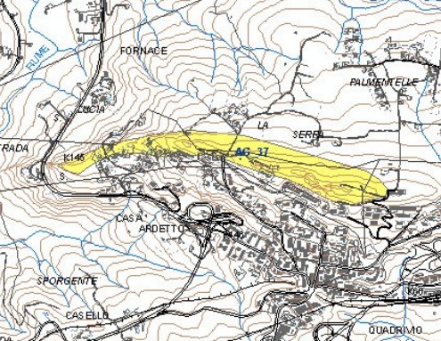
Archaeological site of Serraferlicchio
The site affects the crest of a hill, approx. 1 km east-west and narrow a few hundred meters, overlooking a recently urbanized neighborhood. On the summit plateau the remains of an Eneolithic village with oval huts and central hearths were found, which has returned abundant pottery characterized by…. On the eastern slope was the coeval necropolis with oven tombs. In addition, it is worth noting the presence of a natural tunnel approx. 100 meters and 0,70 meters wide with an axis coinciding with that of the hill in which pottery was found, interpreted by scholars as a natural drain of the village above. The site is eponymous with a cultural facies of the early Eneolithic period. - Eneolithic - II-II millennium BC Area of Archaeological Interest art. 142 lett. m) Legislative Decree 42/04
(Source text of survey form n.238 Landscape Plan of the Province of Agrigento - Archaeological Heritage)
Archaeological Heritage Sheets Landscape Plan of Agrigento
PRESS: Well cataloged but not geolocated. We invite you to provide your contribution by providing us with useful information that will allow us to geolocate the listed asset. See also "Cultural Heritage to be Geolocated"
Card insertion: Ignazio Caloggero
Information contributions: Ignazio Caloggero Web
Photo: card 238 cited
Note: The populating of the files of the Heritage database proceeds in incremental phases: cataloging, georeferencing, insertion of information and images. The cultural property in question has been cataloged, georeferenced and the first information entered. In order to enrich the information content, further contributions are welcome, if you wish you can contribute through our area "Your Contributions"
