

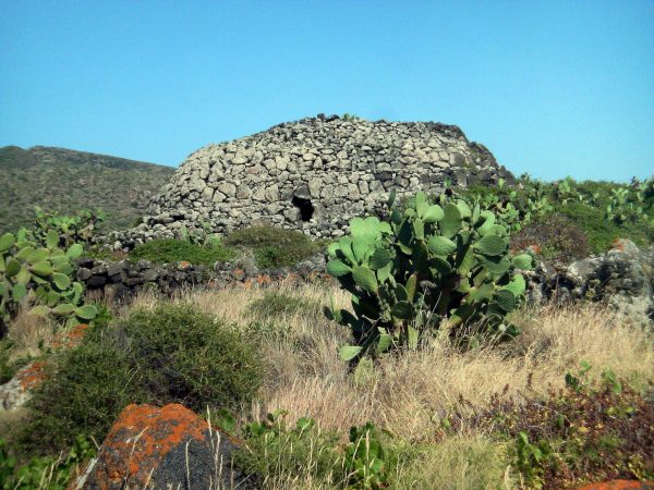
Archaeological Park of the Sesi: Sese Grande
All the known sesi were built in the Cimillia and Mursia districts, around a large fortified settlement, in the north-western portion of the island of Pantelleria.
After the first studies by Guido Dalla Rosa (1870) and Francesco Saverio Cavallari (1874), it was the archaeologist Paolo Orsi with an expedition between 1894 and the following year, who proved that the Sesi were tombs, although his census and the excavations carried out on some monuments did not allow to find any intact burial. In recent years (1997-2008) the researches of Fabrizio Nicoletti and Sebastiano Tusa have made it possible to identify new sesi, two of which have returned for the first time intact funerary depositions.
About a hundred sesi are known on the Pantelleria soil. The largest is the so-called sese Grande or sese del Re, 5,58 meters high and 20 meters in diameter.
The sesi are megalithic constructions, with a circular or elliptical plan, with marked steps ending with a flat surface or a cap. Around the perimeter there are entrances (from two to eleven), each of which, through a rectilinear dolmen corridor, leads to a cell with a circular plan with a marked ogival dome, seat of the burials. The construction technique, which includes a corridor structure characterized by the clear prevalence of the masonry over the empty usable space, finds comparisons in France with some mounds dating back to the Middle Neolithic, such as those of La Nògue, La Noguette, in Calvadòs. (Text source: Wikipedia)
In-depth articles:
Source: web / Wikipedia
In-depth articles:
Card insertion: Ignazio Caloggero
Photo: Di Gino Roncaglia from Rome, Italy - Pantelleria, Sese grande (or 'Sese del Re'), CC BY 2.0, https://commons.wikimedia.org/w/index.php?curid=4985216
Information contributions: Web, Region of Sicily
Note: The populating of the files of the Heritage database proceeds in incremental phases: cataloging, georeferencing, insertion of information and images. The cultural property in question has been cataloged, georeferenced and the first information entered. In order to enrich the information content, further contributions are welcome, if you wish you can contribute through our area "Your Contributions"
