

Mokarta - Cresta del Gallo
Bronze Age settlement and necropolis
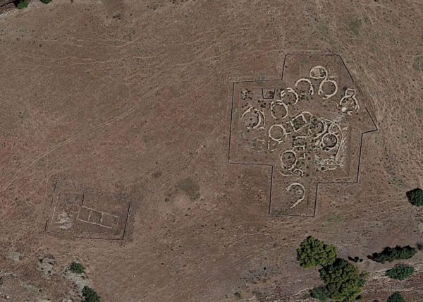
Consisting of circular huts characterized by the peculiarity of a double entrance. Along the sides of the hill a vast necropolis has been investigated with tombs of the "cave" type carved into the rock. As evidenced by the evident traces of destruction, the village was abandoned around the XNUMXth century. BC following a traumatic event, probably an incursion of external populations of the Elymian ethnic group, who at that time settled in the western part of Sicily. In front of the entrance to one of the huts, the skeleton of a young woman was found, probably trapped by the collapse of the roof during the escape. This discovery strengthens the thesis that the village was destroyed and abruptly abandoned.
The tombs with artificial caves, dug into the rock, are about a hundred and consist of a small cell with a circular (average diameter 1.50 m) or elliptical plan. Often the semi-elliptical or quadrangular façade is preceded by a small access corridor (dromos), carved into the rocky wall and with a dome or ogival vault. Inside the tombs, the remains of several burials were found with simple kits consisting of vases, including keeled bowls and cups on the foot side. (Source: Segesta Park)
Area of archaeological interest, art. 142 letter m) Legislative Decree 42/04
Source: Regional landscape plan guidelines + http://map.sitr.regione.sicilia.it/gis/rest/services/Beni_Culturali
In-depth documents:
Giovanni Vultaggio - The results of the surface archaeological research carried out in the Trapani area with the Kalat Project in the three-year period 1995-1997
file downloadable at the following link: https://www.academia.edu/44747870/I_risultati_delle_ricerche_archeologiche_di_superficie_condotte_nell_area_trapanese_con_il_Progetto_Kalat_nel_triennio_1995_1997
Card insertion: Ignazio Caloggero
Information contributions: Web, Region of Sicily
Photo: web
Note: The populating of the files of the Heritage database proceeds in incremental phases: cataloging, georeferencing, insertion of information and images. The cultural property in question has been cataloged, georeferenced and the first information entered. In order to enrich the information content, further contributions are welcome, if you wish you can contribute through our area "Your Contributions"
