

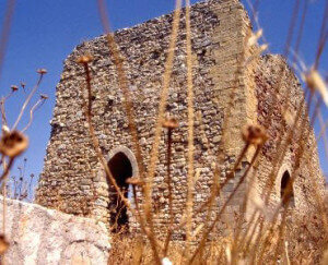
Calathamet Castle - Calatafimi

Calathamet in the eleventh century is a fortified place, mentioned by Edrisi as a strong "fortress", and then by Ibn Gubayr as a "large town" and still literary sources speak of it as a "castrum" with church (Santa Maria di Calathamet), a market, and Arab population of contadini, with baths and mills at the foot of the site. Vito Amico in the Topographical Dictionary of Sicilian Municipalities (Palermo 1855) defines it: “Casale Saracino oppressed by ruins, under Calatafimi, where the thermal waters of Segesta are.
A single-nave chapel leans against the palace and is built on a cistern. Scholars favor a XNUMXth-century construction of both the palace and the Calathamet chapel, subsequent destruction at the time of the Frederick wars, and a XNUMXth-century military reoccupation.
Card insertion: Ignatius Caloggero
Photo: web
Information contributions: Ignazio Caloggero, Region of Sicily, web
Note: The populating of the files of the Heritage database proceeds in incremental phases: cataloging, georeferencing, insertion of information and images. The cultural property in question has been cataloged, georeferenced and the first information entered. In order to enrich the information content, further contributions are welcome, if you wish you can contribute through our area "Your Contributions"
