

Inhabited zone E (Mozia)
Area belonging to the archaeological site of Mozia
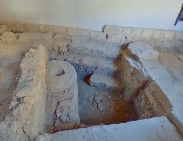
Inhabited Area. E: Three blocks of the ancient town of Mozia discovered during the renovation of the Whitaker Museum.
Inhabited of Mozia.
The central part of the island was occupied by the city proper, with an orthogonal road network, of which only some sections have been brought to light. In the center you can see a stretch of a road oriented in a north-west / south-east direction, bounded by the front of several buildings. A stone placed vertically at an edge, which was to act as a curbstone, reveals the presence of an intersection with an orthogonal road, only partially visible, which must have been parallel to the north gate road. In the paving of the road there are four circular wells, dug into the rock and covered with dry stone, three of which are aligned: they were to be used for the absorption and drainage of water. The complex that overlooks the northern side of the road is accessed through a large threshold in a large room on the back wall of which there is a platform accessible by three steps and with a drainage channel that leads into a well, just in front of it. to the ladder. A second smaller room, long and narrow, has a rectangular counter in the center of the wall, while a third room had a pillar in the center, in which remains of burnt bones were found. The platform of the first room was interpreted as an altar for sacrifices and the complex as a place of worship. Three small rooms, accessed from the street through another threshold, are probably pertinent to another building. In the excavation, materials from the 397th and possibly XNUMXrd century BC were found, therefore after the destruction in XNUMX BC. Traces of alterations are not clearly definable.
Source: wikipedia, web
Photos:
Card insertion: Ignazio Caloggero
Information contributions: Web, Region of Sicily
Note: The populating of the files of the Heritage database proceeds in incremental phases: cataloging, georeferencing, insertion of information and images. The cultural property in question has been cataloged, georeferenced and the first information entered. In order to enrich the information content, further contributions are welcome, if you wish you can contribute through our area "Your Contributions"
