

Ancient Paths and Historical Itineraries of Sicily: IX Via Taormina – Termini Imerese (Taormina – Calabrò section)
Phase B: Rev 1.0 (edited by Ignazio Caloggero)
Interactive map updated in real time. For a global view of all the historical itineraries of Sicily, for the presentation of the project, the "zoomable" historical maps taken as reference and the relative methodological notes, please refer to the project page: Ancient paths and historical itineraries of Sicily. For a view of all the routes in one web page, see: Ancient Paths and Historical Itineraries of Sicily: All the routes live.
The map shows the main "stations" and the archaeological sites encountered along the way. Under the map further details and technical notes.
Description
The route, indicated by Biagio Pace (3.482), is as follows
- Taormina
- Cesarò,
- troina,
- Nicosia
- Hooks
- Petralia
- Caltavuturro,
- Cerda
- Termini Imerese
Summary of the path
- Section IXA (Taormina – Francavilla)
- Section IXB (Francavilla – Cesarò)
- Section IXC (Cesarò – Nicosia)
- Section IXD (Nicosia – Calabrò)
- Section IXE (Calabrò – Termini Imerese)
Section IXA (Taormina – Francavilla)
From Taormina to Giardini Naxos same route as via Pompeia (Messina – Syracuse)
- IXA1.1: Gaggi (C7), (C27)
- IXA1.2: Motta Camastra (near) (C2) (C26), (C7), (C22)
- Francavilla di Sicilia (CAMS) (C20) (C27) (C7 – near), (C2)(C5) (C22)
Section IXB (Francavilla – Cesarò)
- IXB1.1: Brand (CAMS)
- IXB1.2: Castiglione di Sicilia (99) (C22) (C2) (C7)
- IXB1.3: Mojo (C27), (C22) (C5) (C2)
- IXB1.4: Contrada Santa Anastasia (CAMS)
- IXB1.5: Randazzo (3.482) (6) (C22) (C2) (C7)
- IXB1.6: Contrada Donna Bianca (CAMS)
- IXB1.7: Contrade Edera, S. Venera and Balze (CAMS)
- IXB1.8: Fondaco (CAMS)
- IXB1.9: Cesarò (3.482) (C7) (C22) (C27) (C22) (C2) (C7)
Section IXB (Cesarò – Nicosia)
- IXC1.1: Troina (3.482) (6) (CAMS) (C22) (C2) (C7)
- IXC1.2: Contrada Femmemorta (CAMS)
- IXC1.3: Cicero's Bridge (C26)
- IXC1.4: Contrada Castagna (CAMS)
- IXC1.5: Nicosia (3.482) (6) (C2) (C7)
Section IXD (Nicosia – Calabrò)
- IXD1.1: Contrada La Croce (CAMS)
- IXD1.2: Leap of the Red (CAMS)
- IXD1.3: Old Hooks (3.482) (6) (CAMS) (C22) (C2) (C7)
- IXD1.4: Calabro (99)
Section IXE (Calabrò – Termini Imerese)
From Calabrò on to Catania - Termini Imerese
Insights
Section IXA (Taormina – Francavilla)
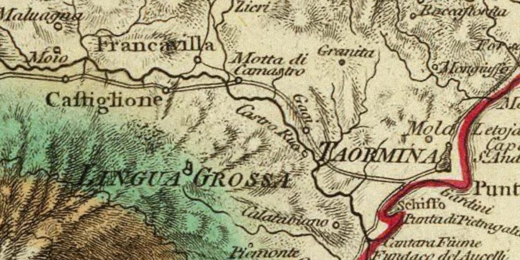
Sicily. Publisher: Robert Laurie & James Whittle - London (1799). Improved card taken from the card of Samuel von Schmettau from 1721.
Bibliography and Reference Cartography.
(1) (3) (7) (9) (13) (99) (CAMS) (C4) C7) (C27)
- [1] Giovanni Uggeri: The formation of the Roman road system in Sicily
- [3] Biagio Pace: Art and Civilization of Ancient Sicily Vol. 1 pag. 453-488
- G. Uggeri: Itineraries and roads, routes, ports and ports of call of late ancient Sicilyin Proceedings IX Ancient Sicily Congress (Palermo 1997), "Kokalos" 43-44 (1997-1998), Rome 2000, pp. 299-364.
- [99] Ignazio Caloggero: The Project Ancient Paths and Historical Itineraries of Sicily
- CAMS: Multimedia Archaeological Map of Sicily - Link: https://www.lasiciliainrete.it/archivio-patrimonio-archeologico-di-sicilia/
- C4: Nova et accurate Siciliae Regionum, Urbium, Castellorum, Pagorum Montium, Sylvarum, Planitierum, Viarum Situum ac Singularium quorumque locorum et rerum ad Geographiam Partinentium Descriptio Universalis - 1721 author Schmettau, Samuel von
- C7: Sicily. Publisher: Robert Laurie & James Whittle (1799) (always referable to the Schmettau paper)
- C27: Comparative Map of Modern Sicily (1859)
For the bibliography and general cartography see the page: Methodological Notes and Bibliography
Technical and methodological note
The Multimedia Map of the Ancient Historical Paths is created in sub-phases (not necessarily sequential):
- Phase A (Basic Path): in the first sub-phase the paths are identified in the form of a first draft divided into segments and sections (taking into account the bibliography, the historical maps analyzed and the Multimedia Archaeological Map of Sicily (CAMS) and only partially the paths on the ground). The basic route is the starting point proposed to the scientific community, preparatory to the subsequent phase of detailed analysis of the individual segments that make up the entire identified path
- Phase B (Advanced Path): in the second phase, an incremental refinement process will begin by adapting, as faithfully as possible, the individual components that make up the route to the historical routes and to the tracks on the ground and where the ancient traces have been lost, adapt them to the current routes that are closest to the ancient paths (keeping track of the historical paths, where identified). The incremental refinement process will also take into account historical roads, natural roads and further studies and contributions from the scientific community and scholars in the sector.
- Phase C (Subdivision of the paths): When fully operational, the project provides for the drafting of two paths that may diverge in some points: a path as faithful as possible to the ancient path regardless of its current practicability and another that could form the basis for proposing itineraries that take into account the actual practicability and the possibility of enjoying the historical, artistic and naturalistic beauties close to the historical route.
Note: In cases where the ancient route is no longer identifiable or has been completely replaced by high-speed roads, or obstructed by industrial plants or other types of impediment, an attempt has been made to identify a stretch that in some way is closest to the characteristics of a naturalistic path or in any case a substitute for the fast-flowing path. In some cases, moreover, in case of doubt between two possible routes, the route that allows you to pass in the immediate vicinity of landscapes or cultural heritage considered interesting from a tourist-cultural point of view has been taken into consideration.
