

Ancient Paths and Historical Itineraries of Sicily: I Via Valeria (Messina Palermo section)
Phase B: Rev 1.1
Interactive map updated in real time. For a global view of all the historical itineraries of Sicily, for the presentation of the project, the "zoomable" historical maps taken as reference and the relative methodological notes, please refer to the project page: Ancient paths and historical itineraries of Sicily. For a view of all the routes in one web page, see: Ancient Paths and Historical Itineraries of Sicily: All the routes live.
The map shows the main "stations" and the archaeological sites encountered along the way. Under the map further details and technical notes.
Description
Summary of traits, sub-tracts and variants
- Section IA (Faro – Messina)
- Section IB (Messina – Ban)
- Section IC (Prohibition – Archi Marina)
- Section ID (Archi Marina – Barcellona Pozzo di Gotto)
- Section IE (Barcelona Pozzo di Gotto – Capo d'Orlando)
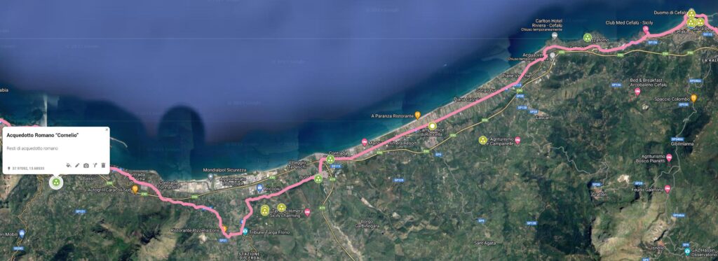
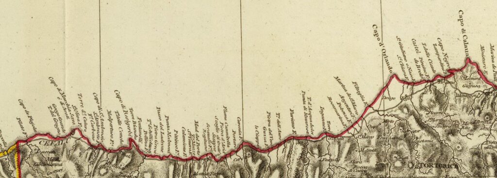
- Section IF (Capo d'Orlando – Cefalù)
- Section IG (Cefalù – Termini Imerese)
- Section IH (Termini Imerese – Palermo)
Transverse and branch
Branch IDIR1: (Archi – Milazzo – Barcellona Pozzo di Gotto)
Below is the detailed description
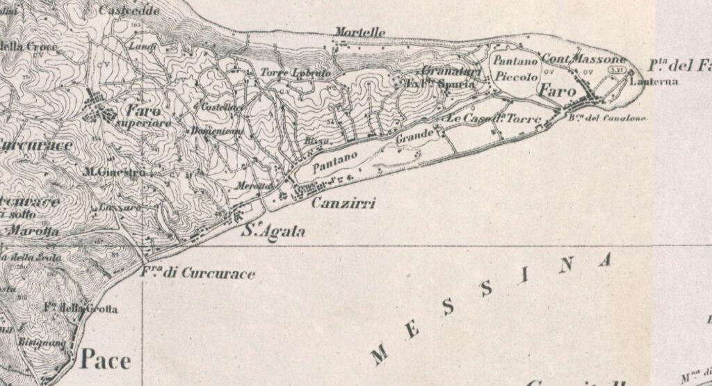
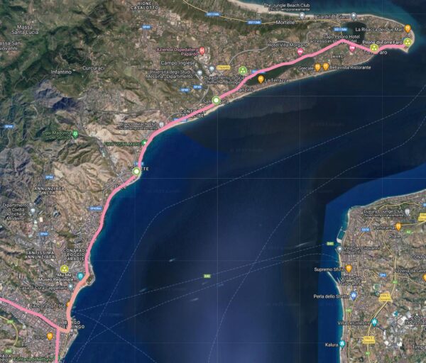
Section IA (Faro – Messina)
- IA.1: Traiecto (Tragecyhus) (Lighthouse) (C14) (C28) (C4-C7) (Colonna del Peloro: 3.465) (CAMS)
- AI.2: Ganzirri (CAMS) (C26) (C4-C7) (C30)
- AI.3: St. Agatha (C26) (C4-C7) (C30)
- AI.4: Peace (C26) (C4-C7) (C30)
- AI.5: Torre Annunziata (C26) (C4-C7) (C30) (CAMS)
- AI.6: San Leone stream (C26) (C4-C7) (C30)
Section IB (Messina – Ban)
- IB.1: Messana (C14) (C28) (C4-C7) (C29)
- IB.2: Michael (3.465)
- IB.3: Portella (3.465) (CAMS) (C26)
- IB.4: Rizzo (C26)
- IB.5: St. Nicholas (C26)
- IB.6: Plaster (3.465) (C26) (C30)
- IB.7: Gregory (3.465) (C30)
- IB.8: Ban (3.465) (C27) (C4-C7) (C26) (C29) (C30)
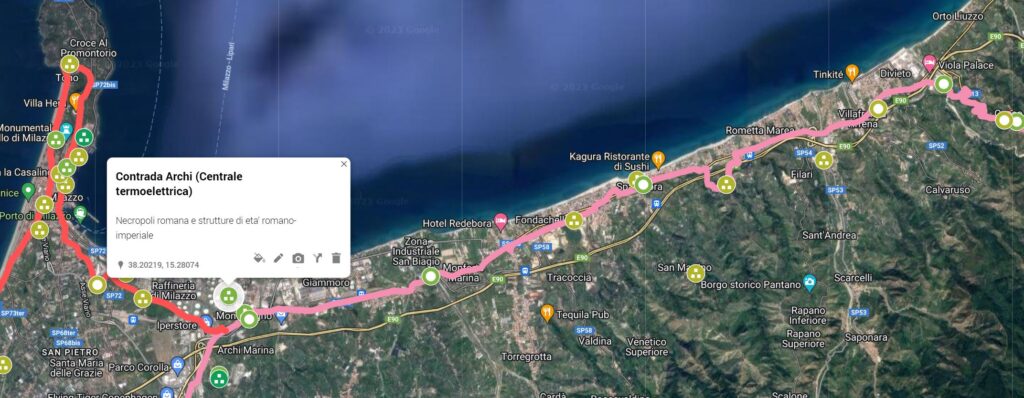
Section IC (Prohibition – Archi Marina)
- IC.1: Bauso (C26) (C30)
- IC.2: Laino (CAMS) (C26) (C30)
- IC.3: Spadafora (CAMS) (C26) (C30)
- IC.4: Scarano (CAMS) (C26) (C30)
- IC.5: San Biagio (C26) (C30)
- IC.6: Strings (3.465) (C4-C7) (C26) (C27) (CAMS) (C26) (C30)
Branch IDIR1: (Archi – Milazzo – Barcellona Pozzo di Gotto)
-
- IDIR.1: Old Park (CAMS)
- IDIR.2: Contrada Palazzo (C26)
- IDIR.3: Milazzo – Location Castello (CAMS) (C4-C7)
- IDIR.4: Contrada Tono (CAMS)
- IDIR.5: St. John (CAMS)
- IDIR.6: Santa Marina (CAMS)
- IDIR.7: The Turret (C26)
- IDIR.8: Barcellona Pozzo di Gotto (C4-C7) (C26) (C27) (C30)
Section ID (Archi Marina – Barcellona Pozzo di Gotto)
-
- ID.1: Reillo-San Domenico (CAMS) (C30) (C26)
- ID.2: Meri (3.466) (8-C4-C7) (C26) (C27) (C30)
- ID.3: Oreto (C30) (CAMS) (C26)
- ID.4: Contrada Cappuccini (C30) (CAMS) (C26)
- Barcellona Pozzo di Gotto (C4-C7) (C26) (C27) (C30)
Section IE (Barcelona Pozzo di Gotto – Capo d'Orlando)
- IE.1: St. Anthony (C4-C7) (C26) (C30 (CAMS)
- IE.2: San Biagio (CAMS) (C30
- IE.3: Casandola (CAMS) (C30
- IE.4: St. Anne (C26) (CAMS) (C30)
- IE.5: Contrada S. Leo (Oliveri) (C26) (CAMS) (C30)
- IE.6: Tindaris (Tindareus) (C14) (C28) (C4-C7) (C28) (C29)
- IE.7: Mount Jupiter (CAMS)
- IE.8: Red Houses (C26)
- IE.9: Pacts (C4-C7) (CAMS)
- IE.10: Aquafic (CAMS) (C30)
- IE.11: Contrada Monte (CAMS) (C30) (C26) C4-C7)
- IE.12: Joyous Old Woman (CAMS) (C30)
- IE.13:Contrada Pileci (CAMS) (C30) (C26)
- IE.14: Rocca Timpi (CAMS)
- IE.15: Piraino (C26) (C4-C7) (C27)
- IE.16: Brolo (C26) (C27) (C20)
- IE.17: Bagnoli (CAMS)
- IE.18: Capo d'Orlando (CAMS) (C26) (C4-C7)
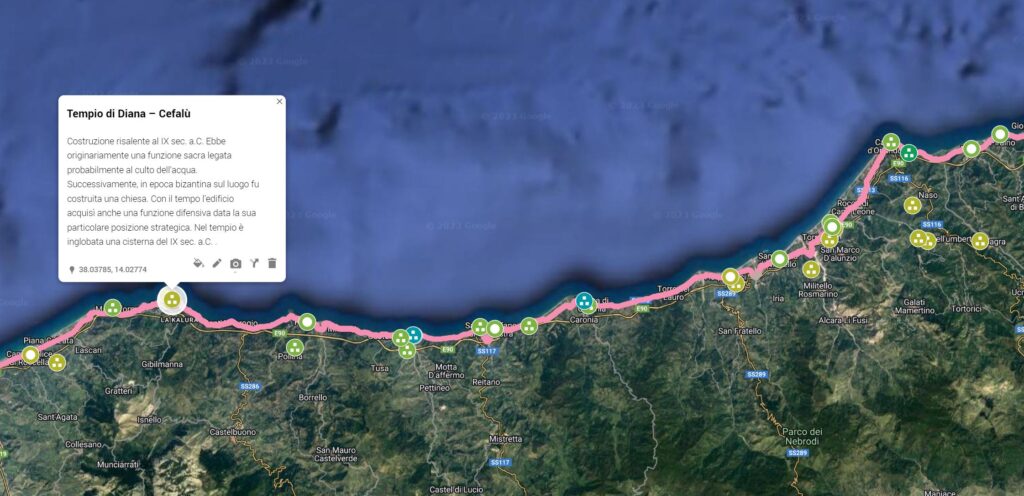
Section IF (Capo d'Orlando – Cefalù)
- IF.1: Scodoni Plan (C26) 8CAMS)
- IF.2: S. Agata di Militelo (Agatirno) (C14) (C28) (C4-C7) (C28) (C29)
- IF.3: Freshwater (C26) (3.468)
- IF.4: Caleate (Calacte) (Caronia) (C14) (C28) (C4-C7) (C28) (CAMS)
- IF.5: Contrada Canneto (CAMS) (C26)
- IF.6: St. Stephen of Camastra (3.468) (C26)
- IF.7: Margie (CAMS)
- IF.8: Haleso (Halesa) (Tusa Castle) (C14) (C28) (C4-C7) (C28) (C29) (CAMS)
- IF.9: Final (C26) (C27) (C20) (C2)
- IF.10: Cephalodo (Cephaledo) (Cefalù) (C14) (C28) (C4-C7) (C29) (CAMS)
Section IG (Cefalù – Termini Imerese)
- IG.1: Contrada Sette frati (CAMS) (C26)
- IG.2: Roccella (C27) (C26)
- IG.3: Contrada Pistavecchia (CAMS)
- IG.4: River Imera (C28) (C26)
- IG.5: Imera plain (CAMS) (C26)
- IG.6: Thermis (Terms) (C28) (C4-C7) (C29) (CAMS)
Section IH (Termini Imerese – Palermo)
- IH.1: Madonna Bridge (C26) (CAMS)
- IH.2: Soluntum (S. Flavia) (C28) (C4-C7)
- IH.3: Santa Flavia (3.468) (C26)
- IH.4: Ficarazzi (C26) (3.468)
- IH.5: Panormo (C14) (C28) (C4-C7)
Insights

C28: Siciliae Antiquae Tabula (1834)
Section IA (Faro – Messina)
C26 – Detail
Section IB (Messina – Ban)

It would be appropriate to investigate the possible branches in blue
Section IC (Prohibition – Archi Marina)
Section ID (Archi Marina – Barcellona Pozzo di Gotto)

The part in red is about the Branch D1: (Archi – Milazzo – Barcellona Pozzo di Gotto)
Section IE (Barcelona Pozzo di Gotto – Capo d'Orlando)

It would be appropriate to investigate the possible branches in blue
Section IF (Capo d'Orlando – Cefalù)
Section IG (Cefalù – Termini Imerese)
C7: Detail
Section IH (Termini Imerese – Palermo)
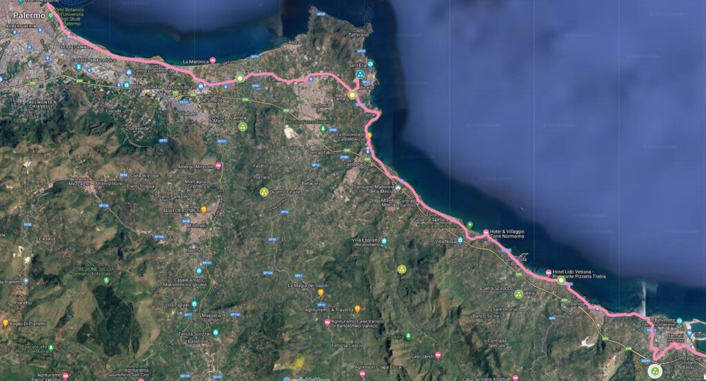
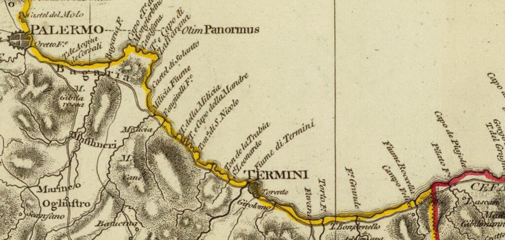
C7: Detail
Bibliography and Reference Cartography.
(1) (3) (13) (15) (17) (22) (36) (40) (42) (59) (60) (99) (CAMS) (C2) (C4) (C7) (C12 ) (C13) (C14) (C15A) (C16) (C17) (C18) (C20) (C26) (C27) (C29) (C30)
- [1] Giovanni Uggeri: The formation of the Roman road system in Sicily
- [3] Biagio Pace: Art and Civilization of Ancient Sicily Vol. 1 pag. 453-488
- [13]: G. Uggeri: Itineraries and roads, routes, ports and ports of call of late ancient Sicilyin Proceedings IX Ancient Sicily Congress (Palermo 1997), "Kokalos" 43-44 (1997-1998), Rome 2000, pp. 299-364.
- [15]: G. Uggeri: The Roman road system in Sicily with particular regard to the third and fourth centuries. In Kokalos XXVIII-XXIX 1982-1983
- [17]: G. Uggeri: Sicily in the "Tabula Peutingeriana" - Editore Loffredo - Naples 1968
- [22] Adolfo Holm History of Sicily Antiquity Vol. III Chap IV
- [36] Tommaso Fazello - History of Sicily Volume I. Palermo
- [40] Thucydides - The Peloponnesian War Vol. VI, VII
- [42] Giorgio Bejor - Aspects of the Romanization of Sicily. In: Modes de contacts et processus de transformation dans les sociétés anciennes. Actes du colloque de Cortone (24-30 mai 1981) Rome: École Française de Rome, 1983. pp. 345-378. (Publications de l'École française de Rome, 67);
- [59]: Angelo Vintaloro - "Atlas of the ancient road system of central-western Sicily" - Editore Archeoclub Alto e Medio Belice Corleonese
- [60] Luigi Santagati: A little light on the Roman Via Valeria. In "Historical and archaeological research in Val Demone - Proceedings of the II conference Barcellona Pozzo di Gotto (ME) Jalari Park - 1 and 2 April 2017"
- [99] Ignazio Caloggero: The Project Ancient Paths and Historical Itineraries of Sicily
- CAMS: Multimedia Archaeological Map of Sicily - Link: https://www.lasiciliainrete.it/archivio-patrimonio-archeologico-di-sicilia/
- C2: Regni & Insvlae Siciliae Tabula geographica ex Archetypo gradiori in hoc compendium redacta - 1747 author: Homann, Johann Baptist
- C4: Nova et accurate Siciliae Regionum, Urbium, Castellorum, Pagorum Montium, Sylvarum, Planitierum, Viarum Situum ac Singularium quorumque locorum et rerum ad Geographiam Partinentium Descriptio Universalis - 1721 author Schmettau, Samuel von
- C7: Sicily. Publisher: Robert Laurie & James Whittle (1799) (always referable to the Schmettau paper)
- C12: Siciliae Antiquae quae et Sicania et Trinacria dicta tabula geographic. Publisher: L'Isle, Guillaume de, 1675-1726
- C13: [4] Tabula Peutingeriana (medieval map of the Roman world written by a monk of Colmar XIII century
- C14: [5] Itinerarium Antonini
- C15A: General Map of the Island of Sicily - Officio Topografico 1826 (South-East)
- C16: Guidelines of the Regional Territorial Landscape Plan - Historic road network
- C17: Syracuse at the time of Gelone and Gelone I map with the roads leaving Syracuse attached to the book by Adolfo Holm: Storia di Sicilia-Vol. THE
- C18: Sicily Trazzerale Network (1929). Published in the Journal of the Land Registry and Tax Services in 1941
- C20: The island of Sicily divided into its valleys. Chamber chalcography (1792) (Rome, Italy) - Author: Ram, de Johannes 1648-1693
- C26: Europe in the XNUMXth century. century (with the Third Military Survey)
- C27: Comparative Map of Modern Sicily (1859)
- C28: Siciliae Antiquae Tabula (1834) (Sicily Tabulae Peutingerianae)
- C29: La Sicile Pour l'Histoire Romaine (1740)
- C30: Cartography of the Landscape Plans of the Sicily Region which can be consulted online (for the trazzere and historical routes)
For the bibliography and general cartography see the page: Methodological Notes and Bibliography
Technical and methodological note
The Multimedia Map of the Ancient Historical Routes is created in two sub-phases (not necessarily sequential):
- Phase A (Basic Path): in the first sub-phase the paths are identified in the form of a first draft divided into segments and sections (taking into account the bibliography, the historical maps analyzed and the Multimedia Archaeological Map of Sicily (CAMS) and only partially the paths on the ground). The basic route is the starting point proposed to the scientific community, preparatory to the subsequent phase of detailed analysis of the individual segments that make up the entire identified path
- Phase B (Advanced Path): in the second phase, an incremental refinement process will begin by adapting, as faithfully as possible, the individual components that make up the route to the historical routes and to the tracks on the ground and where the ancient traces have been lost, adapt them to the current routes that are closest to the ancient paths (keeping track of the historical paths, where identified). The incremental refinement process will also take into account historical roads, natural roads and further studies and contributions from the scientific community and scholars in the sector.
- Phase C (Subdivision of the paths): When fully operational, the project provides for the drafting of two paths that may diverge in some points: a path as faithful as possible to the ancient path regardless of its current practicability and another that could form the basis for proposing itineraries that take into account the actual practicability and the possibility of enjoying the historical, artistic and naturalistic beauties close to the historical route.
Note: In cases where the ancient route is no longer identifiable or has been completely replaced by high-speed roads, or obstructed by industrial plants or other types of impediment, an attempt has been made to identify a stretch that in some way is closest to the characteristics of a naturalistic path or in any case a substitute for the fast-flowing path. In some cases, moreover, in case of doubt between two possible routes, the route that allows you to pass in the immediate vicinity of landscapes or cultural heritage considered interesting from a tourist-cultural point of view has been taken into consideration.
