

Pirozza Spreader
The Pirozza when I went to explore it was impassable because it was covered with dense Mediterranean vegetation and towards the north I found a landfill of all kinds of waste from the neighboring tourist village. I talked about it because it is still a topographically suspected site. The area in the SAS cartography brings the heights from 51,3 to 51,9, which denote a flat surface that is certainly not natural, has a slightly rhomboid shape of about 50 × 40 m, about 1000 square meters. The bordering area to the east has an altitude of 48,6 m, shows a depression with respect to the surrounding land to make one think of the three eddies reported by Calcara. As far as I have reported, the Pirozza is a site with natural characteristics that suggest a fortified settlement very similar to that of Culunnella (Mannino 1991). Now I hope that the Superintendency will no longer spend its energies in
excavate in the Prehistoric Village of the Faraglioni, but if you ever improve its maintenance, and dedicate yourself to the recovery of those monuments that sooner or later private interest will cancel forever. I refer to the Pirozza, the Culunnella, the early Christian tomb of S. Maria and al
so called “Byzantine village” of Spalmatore. The site where I found the Neolithic fragments is on the southern slope of the Tourist Village bordering the Pirozza and concerns the small flower beds around bungalow n. 338, 339, 340, 341. In the same land there are also other types, it is therefore a backfill that I believe was taken from the area of the same village. In three inspections, collaborated by Vito Ailara. Gaetano Russo and Salvatore Pandolfo have been collected 667 fragments that are reflected in different cultures of Sicilian prehistory, starting from various vases of the Neolithic, the Eneolithic, the Bronze and even some fragments of Hellenistic pottery. F ° 249 IV NE, Ustica Island; UTM: UC39908495, Altitude: 60 m.
Text source: Giovanni Mannino: Guide to the Prehistory of Palermo - List of prehistoric sites in the province of Palermo - Sicilian Institute for Political and Economic Studies)
PRESS: Well cataloged but partially geolocated. We invite you to provide your contribution by providing us with useful information that will allow us to geolocate the listed asset. See also "Cultural Heritage to be Geolocated"
Bibliography and further in-depth documents:
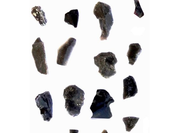
Franco Foresta Martin, Robert H. Tykot Characterization and Provenance of Archaeological Obsidian from Pirozza Spalmatore, a Site of Neolithic Colonization on the Island of Ustica (Sicily) 2019
Download file: 10.1515_opar-2019-0002
100) FIRST SICILY - AT THE ORIGINS OF SICILIAN SOCIETY - volume first edited by Sebastiano Tusa Palermo 1997.
Ignazio Caloggero: Sicily between History, Myths and Legends. Vol. 1: From Prehistory to the Phoenicians. First edition 2018 - Revised and updated edition of 2022
Ignazio Caloggero:
History of Sicily - 1.3.1: Neolithic and the birth of agriculture in Sicily
History of Sicily - 1.3.2: Religiosity and Burials in the Neolithic Period
History of Sicily - 1.3.3: Art in the Neolithic
History of Sicily - 1.3.4: Neolithic Sites List
History of Sicily - 1.4.1: The development of metallurgy
History of Sicily - 1.4.2: Social and cultural development
History of Sicily - 1.4.3: Burials during the Metal Age
History of Sicily - 1.4.4: Religious sentiments during the metal age
Card insertion:
Photo: Obsidian from Pirozza. Fig. 8 Franco Foresta Martin, Robert H. Tykot Characterization and Provenance of Archaeological Obsidian from Pirozza Spalmatore, a Site of Neolithic Colonization on the Island of Ustica (Sicily) 2019
Information contributions: Ignazio Caloggero Web
Note: The populating of the files of the Heritage database proceeds in incremental phases: cataloging, georeferencing, insertion of information and images. The cultural property in question has been cataloged, georeferenced and the first information entered. In order to enrich the information content, further contributions are welcome, if you wish you can contribute through our area "Your Contributions"
