

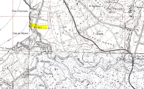
Caves S. Cataldo 1st and 2nd
Purely indicative georeferencing. To review!!
The name comes from a small church in a small hill north east of the Nocella River. The caves open into an old shore line upstream of the SS. 113 km 302,3. The surface is very degraded, however in the 60s several lithic tools of the upper Paleolithic were collected.
F ° 249 III NO, Capo Rama; UTM: UC317175, Altitude: 70-75 m, Development 10, 6 m.
Text source: Giovanni Mannino: Guide to the Prehistory of Palermo - List of prehistoric sites in the province of Palermo - Sicilian Institute for Political and Economic Studies)
Bibliography and further in-depth documents:
100) FIRST SICILY - AT THE ORIGINS OF SICILIAN SOCIETY - volume first edited by Sebastiano Tusa Palermo 1997.
Ignazio Caloggero: Sicily between History, Myths and Legends. Vol. 1: From Prehistory to the Phoenicians. First edition 2018 - Revised and updated edition of 2022
Ignazio Caloggero:
History of Sicily - 1.2. Paleolithic and Mesolithic:
History of Sicily - 1.2.1: Religious sentiments and burials in the Paleolithic and Mesolithic
History of Sicily - 1.2.2: Art in the Paleolithic and Mesolithic
History of Sicily - 1.2.3: Archaeological sites of the Sicilian Paleolithic and Mesolithic
Photos:
Information contributions: Ignazio Caloggero Web
PRESS: Well cataloged but partially geolocated. We invite you to provide your contribution by providing us with useful information that will allow us to geolocate the listed asset. See also "Cultural Heritage to be Geolocated"
Note: The populating of the files of the Heritage database proceeds in incremental phases: cataloging, georeferencing, insertion of information and images. The cultural property in question has been cataloged, georeferenced and the first information entered. In order to enrich the information content, further contributions are welcome, if you wish you can contribute through our area "Your Contributions"
