Fortifications (Mozia)
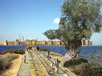
The walls, about 2,5 km long, enclose the whole island and are founded on the bank in limestone tender that rises just (about 2-3 meters) on the very short beach. Remains of it are preserved above all in the parts of the south-east, east and north (the structures were at times still standing in Seventeenth century and in eighteenth century). The remains visible today, the result of different phases of construction and restoration, always on the same route, are presented with masonry in splinters of rock or squared blocks of various sizes or with other simpler techniques. Four major phases have been identified, between the second half of VI and the end of 5th century BC Some restorations, with reconstructions of the upper parts in bricks they appear to be subsequent to the conquest Syracusan of the 397 BC:
- first stage, with a wall (about 1-1,10 m thick) and rectangular towers with two rooms (about 8 × 5,50 m), in small stones; regular distance between the two towers of about 20-21 m;
- second stage, with wall (thickness about 2,60 m), with medium-large stone plinth and raised in raw bricks, one often opens in the middle of the curtain postern;
- third stage, with external facing wall in square work, with blocks arranged on site by head and by cut; quadrangular towers (average 12 × 5 m) and previous towers readjusted; raised perhaps in unfired bricks;
- fourth phase, with a wall (about 5 m thick) in splinters of rock, square towers (about 12 × 12 m) or adapted.
The first phase refers to a first unitary installation of the wall, with precise measurements and the series of close towers that recalls the defensive techniques recurrent in the Near East ancient. The building activity of the subsequent phases, on the other hand, only involved restorations in the sectors that presented the need. The reconstructions of the fourth phase, which required the transport of large quantities of building material not present on the island.
Source: wikipedia
Photo: Di b.roveran - Flickr: SICILY 2009 Isola di Mozia, CC BY 2.0, https://commons.wikimedia.org/w/index.php?curid=12840167
Card insertion: Ignazio Caloggero
Information contributions: Web, Region of Sicily
Note: The populating of the files of the Heritage database proceeds in incremental phases: cataloging, georeferencing, insertion of information and images. The cultural property in question has been cataloged, georeferenced and the first information entered. In order to enrich the information content, further contributions are welcome, if you wish you can contribute through our area "Your Contributions"


