


Comunelli state-owned equipped area
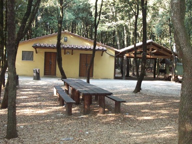
Starting from Butera, take the Provincial Road in the direction of Gela, towards the Comunelli Dam. After about 6 Km. On the right you follow the indication "Vasche Rizzuto", and about 1 Km. You will meet a large sign with the words "Parco equipped Comunelli", the destination of our trip. The wooded complex had begun shortly before and the beauty of the place had already been foretold. The stand is made up of old-style eucalyptus and Mediterranean pines, interspersed with the former, and which, in the medium-long term, will be able to replace the eucalyptus. The area extended about 2 hectares, consists of 20 wooden tables of characteristic invoice, many benches, about 20 fire points, three fountains, a local stone basin, several wooden waste bins, a parking area, swings and a play area for children on the very characteristic “fort” model and made entirely of local wood. The toilets were built by renovating an old building near the area. It is possible to make excursions on foot along the paths that wind through the state property. From the equipped area it is possible to see the Comunelli Dam, which gave the wooded complex its name.
Municipality of Butera
<!– 12000
20
-> Presence of architectural barriers
2 toilet
3 games: swing
Possibility of picnics thanks to: 20 cooking points, 35 tables, for a total of 420 seats
3 points of non-drinking water
Height 300 M.
Managing Body
Department of Regional State Forestry Company
Provincial Office of the Caltanissetta Company
Synthetic symbols used
To describe the symbols, place the mouse over the symbol itself.


Note : The population of the cards of the Heritage database proceeds in incremental phases: cataloging, georeferencing, insertion of information and images. The cultural property in question has been cataloged, georeferenced and the first information entered. In order to enrich the informative contents, further contributions are welcome, if you wish you can contribute by providing information and / or images also through the facebook group "Heritage Sicily"
Find out more on Data bank of the Material Heritage of Sicily
Get to know the Sicilian Cultural Heritage databases: Data Maps Heritage
*******
Note on Sources
The information on the equipped state-owned areas has as its main source the website of the Regional Forestry Department of Sicily (continuously updated) to which is added a very interesting brochure entitled "The State Equipped Areas in Sicily" of the same department published in 1999 with the Editorial Coordination of the 8th Group - Promotion, Development and Research, editors Agostino Gatto and Valeria Restuccia. Further information was obtained from direct access to the areas and from interviews with experts and operators in the sector.
For official information and updates to the lists, see the pages of the site of the Sicily region - Department of the Regional State Forestry Company
